Feeds:
Posts
Comentários

Posts Tagged ‘Standing Stones of Stenness’


Standing Stones of Stenness: the oldest monument at the World Heritage Center./
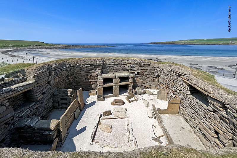
O monumento mais antigo deste Patrimônio Mundial.

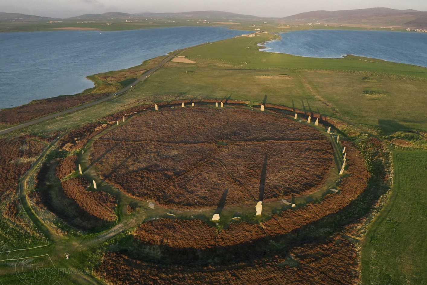
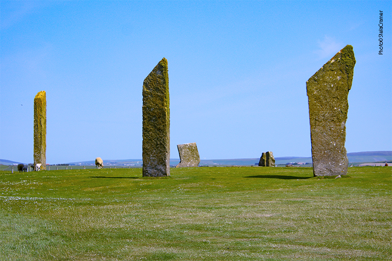
Escavações mostraram que este sítio era, originalmente, um círculo de pedras – possivelmente o mais antigo nas Ilhas Britânicas. Embora atualmente não exista mais o fosso ao redor das pedras – desgastado por séculos de lavoura – confirmaram que o mesmo tinha dois metros de profundidade, cercando uma área de 44m de diâmetro. Originalmente havia pelo menos 11 monolitos, dos quais restam apenas 4, e alguns cotocos.

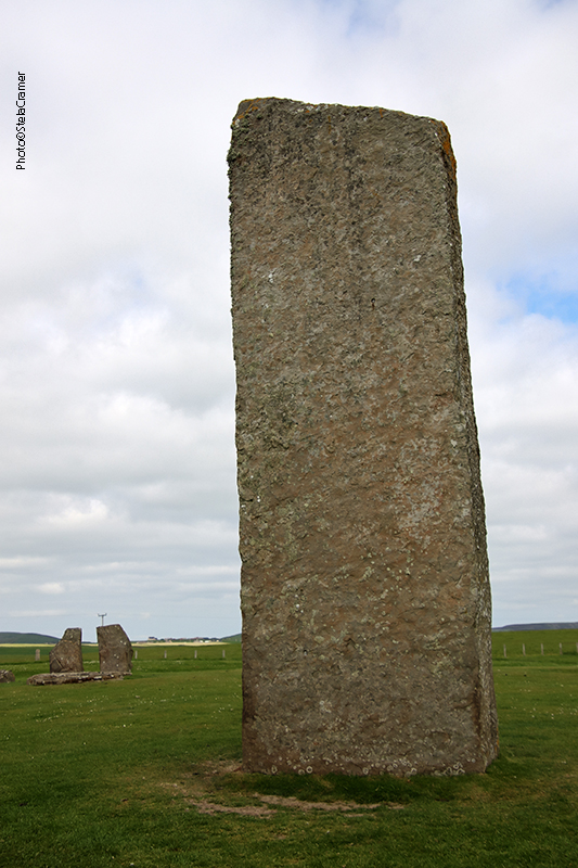
Although the site today lacks the encircling ditch and bank, excavation has shown this site was a henge monument, possibly the oldest in the British Isles. In Neolithical times, the stone ring had been entirely surrounded by a ditch, two metres (6.5 ft) deep, surrounding an area 44 metres (144 ft) in diameter. Centuries of ploughing have almost entirely removed the henge which once enclosed the (at least 11) standing stones, of which only four survive today, and some stumps.

A Sentinela, às margens da lagoa (de água salgada) de Stenness. Do outro lado da estrada temos o lago de Harray, de água doce, o maior das Orkneys./ The Watchstone, by the shore of Loch of Stenness – a salt water (saline) lagoon. The freshwater Loch of Harray, on the other side of the road, is the largest loch of Mainland Orkney.

Em dezembro de 1814, um fazendeiro resolveu remover as pedras, pois lhe incomodava a quantidade de gente que invadia a propriedade para fazer rituais junto às pedras. Ele começou demolindo a Pedra de Odin, para ultraje geral. Quando, por fim, conseguiram fazê-lo parar, ele já tinha derrubado duas outras pedras.

A Pedra de Odin, à qual se atribuíam poderes mágicos, ficava ao norte do círculo. A pedra tinha um furo circular, através do qual casais tradicionalmente davam as mãos para assumir seu compromisso. Outras cerimônias eram realizadas ali, inclusive promessas e juramentos eram feitos pondo a mão na pedra – o chamado Voto de Odin.

Ilustração do sec.18 mostrando a Pedra de Odin e a Sentinela, no caminho para ao Anel de Brodgar. / A 18th-century illustration shows the lost Odin Stone and the Watchstone, by the road to the ring of Brodgar.

In December 1814 a tenant farmer in the vicinity of the stones, decided to remove them on the grounds that local people were trespassing and disturbing his land by using the stones in rituals. He started by smashing the Odin Stone. This caused outrage and he was eventually stopped, but two more stones had already been destroyed.

The Odin Stone, believed to have magical power, stood in the field to the north of the henge. It was pierced with a circular hole, and was used by local couples for plighting engagements by holding hands through the gap. Other ceremonies took place there, including the “Vow of Odin” – a tradition of making oaths or promises with one’s hand in the Odin Stone.

Na década de 70 a pedra que ficava sobre estas duas, como o tampo de uma mesa, foi retirada pois havia dúvida quanto à sua autenticidade. Os “pés” da mesa permanecem no lugar. / In the 1970s, a dolmen structure was toppled, since there were doubts as to its authenticity. The two upright stones remain in place.

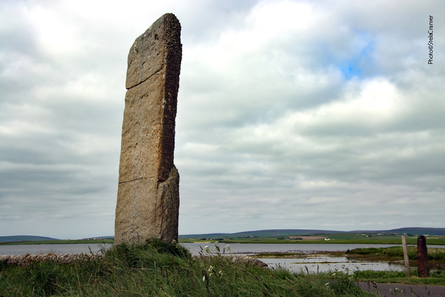
Análise geológica dos monolitos revelou que cinco diferentes tipos de pedras foram utilizadas. Esta descoberta reforça a teoria de que, assim como em Brodgar, as pedras foram trazidas de diferentes lugares, provavelmente significativos, para a construção do monumento.
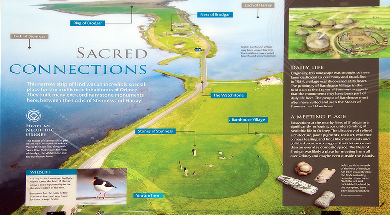
A construção de um círculo de pedras envolvia considerável esforço da comunidade, envolvendo atividades “especializadas” como planejamento, extração das pedras, transporte, construção de fundações e a construção final. Os círculos mais antigos no Reino Unido – Stenness e Callanish (este na Ilha de Lewis) – foram construídos alinhados com a posição do Sol e da Lua. Mas não há consenso entre os arqueólogos quanto à sua função. Poderiam ter sido locais cerimoniais, rituais, sociais, mortuários, para reuniões comunitárias…ninguém sabe ao certo. Eu acrescentaria pontos de comércio a essa lista de possibilidades.

Geological examinations of the surviving stones revealed that five different types of stone were used – a discovery that reinforces the theory that the stones for the monument, just like Brodgar, were brought to the site from various different, perhaps significant, locations.

A stone circle construction often involved considerable communal effort, including specialist tasks such as planning, quarrying, transportation, laying the foundation trenches, and final construction. The two oldest stone circles in Britain – Stenness and Callanish (this on the Isle of Lewis) – were constructed to align with solar and lunar positions. But no consensus exists among archaeologists regarding their intended function: places of ceremony, worship, burial grounds, social gathering places… nobody knows for sure. I’d add trade spots to the list.

Lareira no centro do círculo, semelhante à da Estrutura 8 em Barnhouse Village, que veremos no próximo post / Hearth at the center, similar to the one found in Barnhouse Village’s Structure 8, topic of our next post.
Placas informativas em Stenness. A de baixo mostra a conexão entre os monumentos, incluindo Barnhouse Village, que visitaremos a seguir. /Signs at the Stenness site. The one below shows how interconected the monuments were, including the Barnhouse Village, which we’ll visit next.
Eu fui! / I’ve been there!

Read Full Post »


Vista aérea do Círculo de Brodgar, no istmo entre os lagos de Stenness e Harray. / Aerial view of Ring of Brodgar, in a istmus between the Lochs of Stenness and Harray.

O impressionante Anel de Brodgar não é uma estrutura solta na paisagem. Faz parte de um conjunto de monumentos Neolíticos em Mainland (maior parte do território) das Ilhas Orkney, na Escócia. O conjunto foi batizado de Coração Neolítico de Orkney, nome adotado pela UNESCO quando o sítio foi oficialmente declarado Patrimônio Mundial, em Dezembro de 1999.

The impressive Ring of Brodgar is not a single structure in the landscape. It stands as one of the Neolithic monuments on the Mainland of the Orkney Islands, Scotland. The group is called Heart of Neolithic Orkney, name adopted by UNESCO when it proclaimed these sites as a World Heritage Site in December 1999.

O Coração Neolítico de Orkney / The Heart of Neolithic Orkney

Os quatro monumentos que formam o Coração Neolítico de Orkney estão, sem sombra de dúvida, entre os mais importantes da Europa Ocidental: uma câmara mortuária (Maeshowe), dois círculos de pedras (Stones of Stenness and the Ring of Brodgar) e um povoado em excepcional estado de preservação (Skara Brae), além de túmulos, habitações e locais cerimoniais ainda não escavados. Juntos, constituem uma formidável paisagem pré-histórica que nos permite vislumbrar como viviam as pessoas neste longínquo arquipélago ao norte da Escócia, há cerca de 5000 anos atrás.

The Barnhouse Stone, Maeshowe Chambered tomb in the background

The four monuments that make up the Heart of Neolithic Orkney are unquestionably among the most important Neolithic sites in Western Europe: a large chambered tomb (Maeshowe), two stone circles (the Stones of Stenness and the Ring of Brodgar) and a remarkably well-preserved settlement (Skara Brae), together with a number of unexcavated burial, ceremonial and settlement sites. The group constitutes a major prehistoric cultural landscape which gives a graphic depiction of life in this remote archipelago in the far north of Scotland some 5,000 years ago.

Standing Stones of Stenness
Skara Brae, mais antigo que Stonehenge e Pirâmides de Gizé / A settlement older than Stonehenge and the Great Pyramids of Giza.

Quando comecei a escrever este blog, estava unicamente fascinada pela história do Rei Arthur, pela sua carga mitológica e arquetípica. À medida que fui viajando, lendo e aprendendo, meu foco foi mudando para o conteúdo de realidade que poderia estar contido nos mitos, e as descobertas arqueológicas que os embasavam.

Orkney é um verdadeiro paraíso para pesquisadores e arqueólogos. As 70 ilhas deste arquipélago que agora parece tão remoto já foram um centro de civilização e desenvolvimento, justamente por estarem localizadas ao longo da rota do Mar do Norte, que povos pré históricos trilharam indo do norte da Europa para o atual Reino Unido.
Por exemplo, a sofisticada cerâmica de fundo chato, com sulcos (grooved-ware pottery) teria sua origem em Orkney, 5,100 / 5,300 anos atrás, e esta “tecnologia” dali teria se espalhado para todo o resto da Britânia – assim como outras tecnologias, idéias e estilos de arte. Outro exemplo é o grau de complexidade das habitações em Skara Brae – que possuíam isolamento térmico, mobília e mesmo o mais antigo sanitário britânico.
Este cantinho da Escócia não era apenas um centro de civilização Neolítica. Bem pode ter sido O Centro.

Mapa do Ártico destacando as Orkneys, ao norte da Escócia, Reino Unido /
Arctic Map highlighting the Orkneys, North of Scotland, UK

When I started writing this blog, I was utterly fascinated by King Arthur’s legends, by their mythologic and archetypal contents. As I went on travelling, reading and learning, my focus shifted to the reality that could have been behind the myths, and the archaeological discoveries that supported those.

Orkney is a paradise for researchers. Today, the remote location of the archipelago’s 70 islands seem so remote but, once, it was this very location that made them a centre of civilization. The islands were along the North Sea route that prehistoric people would have taken from northern Europe to Britain and back. Archaeologists have already found, for example, that Orkney invented grooved-ware pottery some 5,100 to 5,300 years ago – a development that later made its way all across Britain, probably accompanied by other types of technology, art and ideas. For example, the buildings of startling sophistication at Skara Brae – the setttlement had insulation, furniture and even what’s thought to be Britain’s earliest toilet ever discovered. This corner of Scotland wasn’t just a centre of Neolithic civilization in Britain. It may have been the centre.

Mapa das Ilhas Orkney destacando Skara Brae e Brodgar /
Orkney Islands map highlighting Skara Brae and Brodgar

Entre o anel de Brodgar e os monolitos de Stenness, há outro importante sítio arqueológico: Ness of Brodgar. Embora não esteja incluído no Patrimônio Mundial, está conectado aos demais monumentos. Estive lá também e breve compartilharei as fotos aqui.

Between the Ring of Brodgar and the Stones of Stenness there’s another important archaeological site: the Ness of Brodgar. It’s connected to the World Heritage Site, although it’s not part of it. I’ve been there too, and the photos will be shared here very soon.

Read Full Post »


Ring of Brodgar, Orkney Islands, Scotland

As Ilhas Orkney se estendem ainda mais ao norte, porém depois da parada em Skara Brae o ônibus volta a Kirkwall, só então passando pelo Anel de Brodgar, mas para minha surpresa não para lá e sim nas Standing Stones of Stenness, um pouco adiante na estrada. “Por que não paramos em Brodgar?” Reclamei com o guia ao ver o enorme círculo de pedra ficar para trás e o veículo estacionar em Stenness. Falei que eu tinha vindo do Brasil para ver o Anel; ele replicou que Stenness tinha maior valor arqueológico e o horário da excursão não comportava visitar os dois, ou perderíamos o último ferry.

The Orkneys are spread further north, but the coach returns to Kirkwall after Skara Brae, and only then it passes by the Ring of Brodgar, but for my astonishment it didn’t stop there! We halted one mile ahead, in the Standing Stones of Stenness. As the massive circle was left behind, I asked the tour guide why was that. I told him I had come all the way from Brazil to see the Ring. He replied that Stenness was archaeologically more relevant, and the tour schedule didn’t allow to stop in both places, otherwise we’d lose the ferryboat.

The Standing Stones of Stenness.
Of course the coach would park in the perfect spot to spoil my picture.
Claro que o ônibus parou no lugar ideal para estragar minha foto.

Na hora aceitei a explicação e fui fotografar as pedras. O tempo estava fechando, o céu se tingia de grafite, e fiquei tentando me convencer de que daria um ar dramático às fotos. Pela milésima vez na vida quis ter asas, que me erguessem pelo menos uns cinco metros do chão, para sobrevoar o local e conseguir por todas as pedras numa mesma foto.

For the moment I accepted the excuse and went strolling among the stones to take pictures. The sunny weather at Skara Brae was quickly turning into a graphite grey sky, and I tried to believe it would add a dramatic atmosphere to the photos. For the thousandth time in life I wish I had wings that could uplift me a few meters, just enough to overfly the place and get all the stones in one single picture.

Barnhouse Stone

Do círculo de pedras se avista Barnhouse Stone, um monólito solitário, e o mound de Maeshowe, uns setecentos metros adiante. Os monumentos ficam todos alinhados, mas só os vimos de longe. Consegui duas fotos do Anel, que ficaram tortas e tremidas através do vidro sujo do ônibus. Um profundo mau humor tomou conta de mim. Estava  revoltada porque não paramos em Brodgar, mas o pior foi que depois disso a excursão parou numa droga de uma capela italiana construída por prisioneiros da Segunda Guerra e lá ficamos meia hora antes de voltarmos ao ferryboat! Meia hora preciosa que poderíamos ter passado em Brodgar. Saí possessa atrás do guia, que, ao ver a minha expressão assassina, desapareceu entre os turistas.

From the Standing Stones of Stenness you spot Barnhouse Stone, a lonely standing stone, and the Maeshowe Mound ahead. All the monuments stay in a line, but we could only see the latest from the distance. I’ve got two photos of the Ring of Brodgar, crooked and blurred through the dusty coach window. A dark mood took hold of me. I couln’t accept missing the Ring, but the worst was yet to come. The tour made one last stop in a stupid Italian Chapel built by II World War prisioners, and remained there for half an hour, thirteen precious minutes stolen from Brodgar! I went after the guide, in rage. The man noticed my murderous look and disappeared among the tourists, aware that I was going to strangle him.

The Italian Chapel and a monument in front of it. What a waste of time.
A capela Italiana e o monumento em frente. Que perda de tempo.

Voltamos a Burwick, onde o ferryboat nos aguardava para os quarenta e cinco minutos de travessia até John O’Groats. Jules ficara íntima do capitão na viagem de ida, mas o frio na volta a deixou mais quieta. Na verdade, quase congelamos. Eram cinco da tarde, o vento norte não dava trégua.
Eu estava arrasada pois queria tanto percorrer o Anel de Brodgar, e o lugar é tão longe que duvidava muito que conseguisse voltar lá um dia para fazer as fotos que perdera hoje. Minha amiga observou que eu tinha “tanto tesão em fotos”, e que eu não devia me sentir assim, que realmente estava chateada sem motivo. Afinal, quantos brasileiros eu conhecia que já tinham estado em Orkney? Provavelmente só eu mesma. E bati tantas fotos quanto comportou a memória da câmera. O problema é que quero sempre mais.

Back to Burwick, the ferryboat was waiting to take us back to John O’Groats, forty five minutes under the unmerciful North Wind. Jules had made friendship with the captain in the outward journey, but now she was silent, such was the cold at 5 pm. We’d nearly frozen. I was devastated because I had been longing so long for a walk in the Ring of Brodgar and that was denied me. I doubted I could ever go back there for the lost pictures. My friend remarked I had “such a lust in photos” and I shouldn’t feel that bad; for how many Brazilians I knew had ever been to the Orkneys? Probably only me. And I took as many pictures as my memory cards could bear.
The problem is, I do always want more.

Despite the frustration, I’ve been able to smile and say a prayer.
Apesar da frustração, fui capaz de fazer uma oração e dar um sorriso.


Read Full Post »