O tour de Rousay terminou com a visita a mais duas câmaras mortuárias: Blackhammer e Taversoe Tuick. Ambas estão protegidas da erosão por uma redoma de concreto. Blackhammer era meio mais do mesmo mas T Tuick foi uma surpresa.
Rousay tour ended with two more burial chambers: Blackhammer e Taversoe Tuick. Both are protected from erosion by a concrete dome. Blackhammer was pretty average but T Tuick held a surprise!
Em Blackhammer foi construída uma clarabóia ao lado da entrada que permite a visão da câmara e iluminação natural. /A skylight built beside the entrance allows the chamber’s view and natural light inside.
A placa mostra um corte de Blackhammer, foto da câmara original e dos arqueólogos que comandaram a escavação em 1936. / The sign shows a section through Blackhammer and photos of the archaeologists and the chamber before being excavated in 1936.
Restos humanos e objetos foram encontrados em Blackhammer./ Human remains and objects were found in the chamber.
Blackhammer Interior
Pouco mais adiante chegamos a Taversoe Tuick, o grand finale do tour. Daqui, Patrick levaria o grupo para pegar o ferry em Trumland Pier de volta a Kirkwall. Eu ainda pernoitei no B&B The Taversoe , só retornaria a Kirkwall na manhã seguinte.
We eventually arrived at Taversoe Tuick, tour’s grand finale. From here, Patrick would drive the group to Trumland Pier, to take the ferry back to Kirkwall. I still stayed the night at The Taversoe B&B, only leaving for Kirkwall the next morning.
A 1km do Trumland Pier, com uma bela vista de Wyre Sound, Taversoe Tuick foi descoberto no fim do século 19, mas a principal escavação aconteceu apenas em 1930. / Situated overlooking Wyre Sound, only half a mile west of Trumland Pier, the Taversoe Tuick was first found in the late 1800s, before being excavated in the 1930s.
Este é o mais extraordinário dos túmulos em Orkney, pois apresenta dois andares. Este design é incomum: até hoje, apenas um outro foi encontrado com a mesma característica, em Eday.
It’s the most remarkable of all the Orkney cairns: a two-storeyed chambered cairn. This design is highly unusual, only another one like it was found ,so far, on Eday.
O grupo examinando a câmara externa de Taverson Tuick, no fim de um canal de pedra. Ao fundo, a bela paisagem de Wyre Sound. / The group examining Taversoe Tuick’s outer chamber at the end of a stone channel; Wyre Sound landscape in the background.
Restos humanos foram encontrados nas duas câmaras, e cacos de cerâmica numa pequena câmara externa, conectada à estrutura principal por um canal feito de pedra. Arqueólogos ainda não sabem qual era a função desta.
Excavations uncovered human remains in both chambers, and pottery shards in an outer chamber too. This outer chamber is connected to the rest of structure by a stone-channel, but there is still discussion about what it was actually used for.
Inside the concrete dome / Interior da cúpula de concreto
As primeiras explorações no séc XIX encontraram ” uma parede bem preservada, com lajes de pedra inseridas verticalmente sobre a câmara subterrânea”. Na época não ficou claro do que se tratava, embora tenha-se discutido a possibilidade de ser uma segunda câmara. Os arqueólogos hesitaram em acreditar serem duas estruturas contemporâneas, pois nunca havia sido encontrado antes uma câmara mortuária de dois andares. Entretanto, as escavações de 1937 confirmaram que era exatamente isso: um andar de cima e um andar de baixo, ambos construídos na mesma época, dentro do mesmo monumento, um bem em cima do outro, cada um com sua entrada separada.
During their 19th century explorations, a “well-preserved, rough-built wall with uprights of stone slabs was found on the ground above the underground chamber”. At the time, what this represented was not clear. It was subsequently mooted to have been a second chamber, but antiquaries were reluctant to believe that the two chambers were contemporary, since “a two-storeyed burial vault would be unprecedented”. The 1937 excavations, however, confirmed that was exactly what it was – an upper storey contemporary with the subterranean chamber, both constructed and enclosed within the same stone cairn, one placed almost exactly over the other and each with a separate entrance passage.
Os dois andares não eram originalmente conectados. Criou-se um acesso por meio de uma escadinha de ferro, num alçapão no chão do andar de cima. A entrada da câmara superior fica do lado norte, voltada para o interior; o acesso à inferior era por uma longa passagem voltada para o sudeste, na direção do mar.
The two layers of the interior were inaccessible from one another. Today they are connected by a hatch in the floor of the upper tomb and a short iron ladder. The upper chamber had its entrance on the north side of the cairn,facing inland, while the lower chamber was entered via a longer passage facing south-east towards the sea.
Antiga entrada da câmara inferior / Lower chamber ancient entrance
A entrada da câmara inferior foi fechada por uma grade de ferro. / The lower chamber entrance passage has been closed with an iron grate.
Entrada da câmara inferior vista de fora / The lower chamber entrance passage from the outside
A escavação em 1937 revelou também que a entrada da câmara superior havia sido bloqueada com alvenaria. Isto não é incomum em túmulos Neolíticos, mas as evidências apontavam claramente para a câmara ter sido selada na Idade do Bronze. Sob a alvenaria, mas 30 cm acima do chão na passagem, estavam os vestígios de um colar: 35 contas e um pendente de pedra-pome perfurados, identificados como da Idade do Bronze, isto é, contemporâneo às urnas de cerâmica que tinham sido encontradas na primeira escavação, 40 anos antes. O fato do colar estar acima do material, mas debaixo do bloqueio, prova que a passagem foi selada na Idade do Bronze. Este e outros achados levam a crer que a importância desta estrutura permaneceu para além do Neolítico e que, aparentemente, foi largamente modificada na Idade do Bronze.
The 1937 excavation also found that the inner end of the upper entrance passage had been blocked with masonry. Again, this is not uncommon in Neolithic chambered cairns but at the Taversoe Tuick the evidence clearly pointed to the chamber being sealed in the Bronze Age. Beneath the blocking material, but 30cm above the passage floor, were the remains of a necklace – 35 stone disc beads and a perforated pumice pendant recognised as Bronze Age, prompting that the necklace, and its deposition, was contemporary with the cists found almost four decades before. The fact the necklace lay on top of material, but beneath the blocking, is proof the passage was sealed in the Bronze Age. This, and other recorded finds, strongly suggests the structure remained a focus long after the Neolithic and, it appears, was also extensively modified in the Bronze Age.
O andar de cima consiste numa área central rodeada por quatro compartimentos. / The upper chamber consists of a central area surrounded by four compartments.
E se fosse o primeiro edifício de apartamentos conhecido na História? Uma família em cada andar…E se os cairns não fossem túmulos, mas simplesmente dormitórios, construídos subterrâneos como proteção contra o frio e predadores? Que falta faz uma máquina do tempo, para nos proporcionar respostas a tantos mistérios.
What if this was History’s first known apartments building? One family on each floor? What if the cairns were not graves but just bedrooms, built underground to protect the inhabitants from the cold and predators? How useful would be a time-machine, to provide us with answers to so many mysteries.
Abaixo um link para o modelo em 3D de Taverson Tuick.
Broch de Gurness em Mainland visto de Rousay / Broch of Gurness in Mainland seen from Rousay
O Estreito de Eynhallow separa a ilha de Rousay de Mainland, a maior ilha das Orkneys, mas de uma se avista a outra. São apenas 3 km de distância. Dois Brochs ficam praticamente de frente um para o outro. Antes de visitar Midhowe vamos dar uma olhada em Rousay, apelidada de “Egito do Norte”, devido à quantidade e importância de sítios arqueológicos.
Eynhallow Sound divides the island of Rousay from Mainland, one in sight of the other, only 3 km apart. Two Brochs almost face each other across the water. Before visiting Midhowe, let’s take a look at Rousay. It has been nicknamed “Egypt of the North”, due to its archaeological diversity and importance.
O ferry liga as ilhas de Rousay, Egilsay e Wyre entre si e com Orkney Mainland. Pode levar até 10 carros e 95 passageiros (no inverno apenas 50). / The ferry links the islands of Rousay, Egilsay, and Wyre with each other, and with the mainland of Orkney. It can take up to 95 passengers (reduced to 50 in winter), and 10 cars.
Depois de dois dias intensos em Westray e Papay (ver posts 167 a 170), peguei o ferry dia 6 de junho/2023 para Kirkwall apenas para pernoitar lá. Consegui um quarto no hotel Ayre, em frente ao terminal do ferry, e bem perto do terminal de ônibus de Kirkwall, assim pude ir andando até a condução para Tingwall, outro terminal de onde sai o ferry para Rousay. Os horários dos ônibus e dos ferrys são todos coordenados. Tinha planejado pegar o primeiro barco mas não foi possível porque precisei antes encontrar uma pessoa, que vinha de Westray trazendo o cartão de crédito que eu tinha perdido lá. O atraso acabou sendo fortuito: o guia Patrick, com quem eu tinha agendado um tour de Rousay, embarcou no mesmo horário. Foi o simpático marinheiro do ferryboat que nos apresentou. Ao me ver na prancha de embarque, correu para me ajudar com a mala e, na conversa que se seguiu, perguntei como chegar ao Taversoe, onde reservara duas noites. Ele respondeu que eu estava com sorte. Patrick era pai da dona do hotel, e me daria uma carona com o maior prazer!
A travessia leva de 20 a 25 minutos / The journey takes approximately 20-25 minutes.
After intense days in Westray and Papay ( see posts 167 to 170), I took the ferry to Kirkwall the 6thJune, just to spend the night there. Got a room at the Ayre hotel, in front of the ferry terminal and walking distance to Kirkwall Travel Centre, where I could take the bus to Tingwall, another ferry terminal that services the Rousay line. The buses and ferries’ schedules are all coordinated. My plan was to board the earliest one, but I couldn’t because I had to meet someone coming from Westray, bringing the Credicard I had lost there. The delay proved fortunate: the guide Patrick, with whom I had booked a Rousay tour, was in the same ferry I took. As I was walking aboard, a lovely sailor hurried to help me with my suitcase and, when I asked him how to get to The Taversoe (where I had booked two nights), he smiled and said that I was lucky. He introduced me to Patrick, who was the Inn owner’s father, and was happy to give me a ride.
Tingwall Terminal
Rousay Ferry Terminal
The Taversoe: o único hotel, bar e restaurante em Rousay, muito bom. / The Taversoe is the only Inn, Bar & Restaurant in Rousay, which I recommend.
Meu quarto era muito confortável, com um bom banheiro e varanda! Abaixo link para o site. / My room was very comfortable, with en-suite bathroom and a porch! Their website is:
A impressionante vista da varanda: Mainland do outro lado do estreito / The stunning view from the porch: Mainland across the water
O Broch de Gurness, que eu iria visitar em breve (ver Post 176), visível da varanda / Broch of Gurness, which I was going to visit soon (see Post 176), in sight from the porch
Foi uma sorte mesmo. Embora a distância fosse de apenas uns 2 a 3 km, consistia em subidas e descidas íngremes e estava chuviscando. Meu tour seria no dia seguinte, o que também foi uma sorte, pois abriu um lindo dia de sol. Aliás o sol apareceu naquele dia mesmo, um pouco mais tarde, apesar do mau tempo pela manhã. Eu já tinha tomado banho, uma pint e estava espichada na varanda do quarto apreciando a bela paisagem. À medida que caía a tarde pensei em dar uma volta, quem sabe capturar um belo por do sol! A mocinha na recepção me sugeriu subir uma trilha próxima, passando por uma pequena ponte, de onde eu teria uma linda vista. E lá fui eu toda contente.
Sol poente, ovelhas e moinhos de vento / Sunset, sheep and wind farm turbines
I was lucky indeed. Although the Inn was just one mile away, the road was steep and a cold drizzle had started. My Island Tour would be the next day, lucky as well because it was a gorgeous sunny day. But the sun reappeared that same day, a bit later, despite the previous bad weather. I had already taken a shower, a pint and was lazying on the porch, reveling in the awesome landscape. As the afternoon approached dusk, I thought of going for a walk, perhaps capture a beautiful sunset. The clerk suggested a trail nearby, that crossed a small bridge, from where I’d have a stunning view. So there I happily went...
A trilha levava a um túmulo! Mais contente ainda, prossegui. The trail led to a chambered cairn! Happier still, I went on.
A ponte indicada existia, mas não dava vista para nada além de mato / The little bridge was there but the view from it was just overgrown bushes
A trilha é quase invisível, mas a vista grandiosa/ The trail is almost invisible, but the view gorgeous
A trilha era praticamente inexistente, um caminho pedregoso no matagal, mais adequado para as ovelhas que por ali estavam do que para gente. Mesmo estas não me pareceram muito amistosas. Se afastaram quando passei, mas ficaram me encarando à distância. Levei quase meia hora para chegar à entrada do túmulo, quase suando apesar do vento frio.
The footpath was almost non-existant, steep, muddy and stony in the weeds, more appropriate to the sheep than to people. Even the sheep didn’t look very friendly. The got away as I went on, but kept staring at me from a distance. It took me around half an hour to reach the cairn. I was almost sweating despite the chilling wind.
Knowe of Yarso data de 3500 a 2500 AC, mas cerâmica ali encontrada sugere que tenha permanecido em uso até 2000AC. O telhado não existe mais, mas as paredes permanecem mais ou menos da altura original. A câmara é dividida por lajes de pedra em compartimentos, semelhante a outras estruturas Neolíticas que visitamos.
Knowe of Yarso dates to between 3500 and 2500 BC, but pottery found inside the tomb suggests it remained in use until the late 2000s BC. Its roof is gone, but the walls still stand close to their original height. The chamber is divided into compartments by upright slabs, similar to other Neolithic structures we’ve seen before.
A entrada original ainda existe, embora o monumento tenha sido encapsulado numa estrutura de concreto com clarabóias e uma porta moderna. / The original entrance remains, although the monument is encapsulated in a sky-lit concrete cap with a modern door.
O fim da câmara / The chamber’s end
Knowe of Yarso é um entre pelo menos 15 outros túmulos semelhantes na pequena ilha. Arqueólogos acreditam que eram usados como cemitérios comunitários. Escavações na década de 30 encontraram os restos de pelo menos 29 esqueletos, e 17 crânios arrumados um ao lado do outro. Ossos de uns 36 cervos também foram desenterrados, assim como pederneiras, ferramentas de osso, pontas de flechas e pedaços de cerâmica. Knowe of Yarso is one of at least 15 chambered tombs on the small island. Archaeologists believe these were used for communal burial. Excavations in the 1930s found the remains of at least 29 skeletons, with 17 skulls arranged side-by-side ; bones from at least 36 deer and also flint, bone tools, arrowheads, and shreds of pottery.
Assim, ali estava eu imersa em pensamentos, absorvendo a atmosfera e tentando bater umas fotos apesar da pouca luz, pois esta vinha por clarabóias cheias de sujeira acumulada, além disso estava escurecendo. Eis que escuto um barulho do lado de fora. As ovelhas tinham vindo até a porta de entrada. Imediatamente meu cérebro foi bombardeado por pensamentos assustadores: e se alguma delas esbarrasse na porta, fechando-a, e eu ficasse presa dentro da tumba? A tranca ficava pelo lado de fora. Meu celular estava com a carga no vermelho, tipo 10%, e ali não tinha sinal. Eu poderia gritar por socorro, mas não havia uma alma por perto para ouvir. Só iriam dar pela minha falta na manhã seguinte, na hora do tour, quando eu já teria com certeza morrido de fome (talvez) e de frio (certamente). Não trouxera mochila nem outro casaco. Rapidamente fiz mais um clique ou dois – inúteis, pois as fotos obviamente ficaram tremidas – e saí correndo.
So, there I was, deep in my thoughts, absorbing the atmosphere and trying to take some pictures in spite of the sparse light flowing through dirt covered skylights; besides, it was dusk. Then I heard a noise outside. The sheep had gathered next to the door. Horrible thoughts came to mind: what if one of them bumped the door closed and I got stuck inside the cairn? The lock was on the outside. My mobile was nearly dead – only 10% charge, and there was no signal. I could scream for help, but there was not a single soul around to hear me. I would only be missed in the morning, for the tour, and by then I’d be dead by starvation (maybe) or cold (definitely). I had no backpack or spare coat. So, I quickly took a couple more pictures – useless, obviously blurred – and ran away.
Run, Stela, run!
Demorei mais para descer a trilha do que para subir, pois já estava quase escuro. Não queria tropeçar e ir rolando os quase 400m até lá embaixo. Ou ir parar dentro do rio, que embora estreito devia ser gelado. As ovelhas ficaram lá de cima me olhando. Mas escapei. It took me longer to get down the trail, because it was almost dark. I didn’t want to risk stumbling and rolling down 400 yards to the road. Or to the river, that was not broad but probably freezing. The sheep stood up there, still staring. But I had escaped.
A salvo, pousada à vista / Safe, the Inn within sight
Compartilhe meu blog se você gostou.Share my blog if you liked it!
Knowth é como Newgrange com mais montinhos / Knowth Megalithic Passage Tomblooks like Newgrange with more mounds
Porém aqui se pode subir no monte principal, com cerca de 12m de altura e 67m de diâmetro. But here you can walk up the main mound, about 40 ft high and 220 ft in diameter.
Tem uma escadaria / There’s a stairway
Um caminho permite que se faça toda a volta no alto do monte. There’s a path to walk all around the top of the mound
Pausa no serviço de manutenção Taking a break in mainteinance service
Painéis mostram a localização de outros marcos na paisagem Signs locate surrounding landmarks
Hill of Slane, indicado à direita, fica a 15 minutos de caminhada do hotel onde me hospedei Hill of Slane, at the right end, was a short walk uphill from my hotel
Newgrange, embora muito próximo, está oculto pelas árvores The trees hide nearby Newgrange
Em volta do monte principal há outros 18 montinhos “satélites” There are 18 smaller satellite mounds around the largest one in Knowth
Não se pode entrar em nenhum, apenas andar em volta You can’t enter the mounds, just stroll around them
Vestígios de outras estruturas / Other structures’ traces
Knowth contém o maior conjunto de Arte Megalítica da Europa. Assim como em Newgrange, as pedras com inscrições foram arrumadas em volta dos montes Knowth contains the largest assemblage of Megalithic Art in Europe. As in Newgrange, the inscribed stones have been placed around the mounds
Mais de 200 pedras com inscrições foram encontradas durante as escavações Over 200 decorated stones were found during excavations
As enormes pedras, chamadas de “kerbstones”, pesam em torno de 5 toneladas cada The boulders, called kerbstones, weigh around 5 tons each
Arqueólogos concluíram que as inscrições representam a lua e ciclos lunares, as mais antigas ilustrações da lua conhecidas em toda a História Archaeologists concluded that the inscriptions refer to the moon and its cicles; these are the oldest known illustration of the moon in history.
A pedra do Relógio de Sol (Kerbstone K15), que aparece no estudo abaixo feito durante a escavação Kerbstone K15, the Sundial Stone, depicted below during the excavation
Muitas pedras tinham os desenhos ocultos, isto é, gravados na parte de baixo ou de trás das pedras. A lot of the art was hidden, i.e. carved onto the reverse or underside of the stones.
O visitante tem mais tempo para observar as pedras em Knowth do que em Newgrange The visitors have more time to see the stones in Knowth than in Newgrange
Uma camada de quartzo branco foi encontrada na entrada do monte principal. O mesmo se encontrava na entrada de Newgrange, e arqueólogos concluíram que devia ser um revestimento de fachada que havia caído. Em Newgrange, foi feita uma “reconstrução”. Em Knowth, deixaram como estava. A layer of white quartz stones was found at the entrances to the great mound. The same was found at the entrance to Newgrange, and the archaeologists concluded that it had been a white façade or revetment on the front of the monument that had fallen. This white quartz front was reconstructed at Newgrange; here it was left where it was.
A orientação leste-oeste das passagens em Knowth sugerem alinhamento com os equinócios. Porém as passagens foram alteradas e destruídas ao longo do tempo, e a construção de uma parede de concreto resultante das escavações (feitas a partir de 1962) impossibilita a investigação de possíveis alinhamentos. The east-west orientation of the passages at Knowth suggests astronomical alignment with the equinoxes. But the passages have been distorted or destroyed by latter settlers, and the erection of a concrete slab wall inside the mound’s west entrance, after excavations (1962 onwards) prevent any investigation into the possible alignments.
Muitas pedras ficam guardadas debaixo dos próprios montes Many stones are kept in “storages” under the mounds
Pedras armazenadas / Stones in storage
Estes troncos assinalam o local de outro monte / These trunks mark another mound’s location
Abaixo link para filmagem por drone, bem bacana / Below, link to a cool drone footage
Uma pena não se poder entrar! Parece tão interessante quanto Newgrange, ou até mais. What a shame, they let nobody in. Looks as interesting as Newgrange, or more. (Photo: Kent Wang, downloaded from Wikipedia.)
Boyne River
Compartilhe meu blog se você gostou.Share my blog if you liked it!
Newgrange é o principal monumento do complexo Brú na Boinne, declarado pela UNESCO Patrimônio Mundial. Construído durante o Neolítico, por volta de 3200 A.C. – mais antigo que Stonehenge e as Pirâmides do Egito – está alinhado ao nascer do sol no Solstício de Inverno. / Newgrange is the main monument in the Brú na Bóinne complex, a UNESCO World Heritage Site. Built during the Neolithic Period, around 3200 BC- older than Stonehenge and the Egyptian pyramids – it is aligned on the winter solstice sunrise.
Eu sempre quis visitar Newgrange, por ser um complemento de Stonehenge. Enquanto Stonehenge marca o Solstício de verão, Newgrange assinala o de Inverno, dia 21 de dezembro. O número de visitantes para essa celebração é limitado e as pessoas escolhidas por sorteio. Preenchi o cupom e deixei meu nome na urna, mas não tive a felicidade de ser contemplada…
Newgrange has always been in my travel wishlist, because it’s an adjunct to Stonehenge. While Stonehenge marks the Summer Solstice, in Newgrange the Winter Solstice, 21th December, is the highlight. There are limited spots to attend to the celebration, and people are chosen by lottery. I have filled the form and put my name in the ballot, but unfortunately haven’t been chosen.
Entrada do Centro de Visitantes / Visitor Center entrance
Desembarquei em Dublin, dia 19 de Maio de 2023, muito animada para passar dois dias nesta cidade e depois seguir para o Vale do Rio Boyne, onde fica Newgrange, assim como outros monumentos. Tinha reservado duas noites em Slane, uma pequena cidade que me parecia bem central na região. Minha intenção era alugar um carro, mas depois de dois dias pegando excursões desanimei: o trânsito parecia bem confuso nos arredores de Dublin, e seria uma longa viagem na auto estrada, especialmente dirigindo na mão inglesa. Então peguei o trem para Drogheda, a estação mais próxima. Depois me arrependi por não ter tentado alugar um carro lá. Só o taxi para Slane já custou caro – 20 libras.
Mapa do local. Dowth é outra Tumba de Passagem próxima, de visitação livre, com acesso pela estrada N51/ Area map. Dowth Passage Tomb nearby has free access from the N51 road.
I was very excited when I got off the plane in Dublin in 19th May 2023, ready to spend a couple days there before departing to Boyne Valley, where Newgrange and many other monuments stand. I had booked a couple nights in Slane, a village that seemed central to the area. I intended to rent a car, but two days of tours made me change my mind: traffic could a bit complicated on Dublin’s outskirts and it was a long drive in the highway… right-hand driving. So I took a train to Drogheda, the closest station. There I should have tried renting a car! The taxi to Sloane itself was very expensive, 20 pounds.
Rio Boyne / Boyne River
Meu hotel ficava ao lado do Centro de Informações de Turismo, assim bati lá para me informar sobre transporte para o Centro de Visitantes de Brú na Bóinne, de onde sai a visita a Newgrange e Knowth. Parecia complicado. A atendente já estava há dez minutos pesquisando horários de ônibus quando a resposta à minha questão adentrou o recinto. Um homem, conhecido do pessoal ali, estava levando seus cartões de visita recém impressos para deixar no balcão. Ele tinha se aposentado e estava começando a trabalhar com táxi. Ficou bem surpreso quando virei para ele e declarei que seria sua primeira cliente. Combinamos então que na manhã seguinte ele me levaria a Monasterboice, Mellifont Abbey (um cemitério e uma abadia em ruínas), e por fim me deixaria no Centro de Visitantes de Brú na Boinne, onde minha visita estava marcada para 2 da tarde. Eu tinha comprado o ingresso online dois meses antes, pelo site cujo link deixo abaixo. O acesso aos monumentos é feito por micro ônibus, limitado a 16 pessoas de cada vez, saindo do Centro de Visitantes. Primeiro o grupo para em Knowth por cerca de meia hora, e só depois segue para Newgrange em si. É fundamental comprar com antecedência pois, lá na hora, você não consegue lugar.
Os grupos vão e voltam do Centro de Visitantes até os monumentos neste micro ônibus./ This shuttle takes the visitor groups from Visitor Centre to the monuments and back
My hotel was next door to Tourist Information Office, so I went there to ask about transport to Brú na Bóinne Visitor Centre, where the Newgrange/ Knowth tours start. Apparently it was not so easy, because after ten minutes perusing bus schedules the clerk hadn’t got an answer yet. Then my answer just walked in! A guy (who knew all the ladies there) came to leave his just printed contact cards. He had retired an was starting in the taxi business, being positively surprised when I looked at him and said: “ I’ll be your first client!” We arranged for next day a visit to some places of interest ( Monasterboice and Mellifont Abbey), ending at the Visitor’s Centre, where he would leave me. My visit was scheduled for 2 p.m.; I had bought the ticket online at the website (link above shuttle picture) two months before. You can’t go to Newgrange on your own. Visitors are brought via shuttle bus to these monuments and pre-booking tickets is essential. The shuttle takes groups of 16 people, first to Knowth (giving you around half an hour to visit it) and eventually to Newgrange itself.
É possível avistar Newgrange do alto do Centro de Visitantes / It’s possible to see Newgrange from the Visitor Centre’s higher floor
A imponente entrada com a pedra entalhada em “triskeles” – espirais triplas. Esta pedra mede cerca de 3 m de comprimento por 1,2m de altura, e pesa cerca de 5 toneladas. / The entrance passage and entrance stone’s triskele-like features, approximately three metres long and 1.2 metres high, and about five tons in weight.
Vista aérea / Aerial view, photo by Heritage Ireland
Cheguei mais cedo para ter tempo de visitar o Centro, a loja de souvenirs e almoçar no restaurante. A opção sopa+sanduíche é sempre uma boa: barata, nutritiva, gostosa e não demora. Embora eu estivesse agendada para 2h, me puseram no ônibus que saía às 3h para os monumentos, no penúltimo grupo. O guia não era nada simpático e se esquivava de responder muitas perguntas, dizendo sempre que falaria sobre isso quando chegássemos lá… assim, jamais respondeu, até porque é outro guia que leva as pessoas para o interior da câmara. Ele parecia só estar esperando para nos conduzir de volta e ir embora.
I arrived early at the Visitor Centre, so there was plenty of time to stroll the facilities, souvenir shop and have lunch at the restaurant. The option soup+sandwich is always a good choice: cheap, tasteful, nourishing and quick. Although my schedule was for 2 p.m. they put me in the 3 p.m. group to the monuments, almost the last one. The guide wasn’t exactly friendly, and to most questions, he said that he would answer later, at the monument… what never happened. Actually, it was another guide who led people inside the chamber. He just stayed there waiting to drive people back and call it a day.
O monumento é cercado por um círculo de pedras. 12 pedras restam das supostas 35 originais. / The mound is also ringed by a stone circle. Twelve standing-stones survive out of a possible original thirty-five.
Algumas das pedras que formam um círculo em volta do monumento / Some of the Standing Stones that surround the monument
Exemplos de arte gráfica Neolítica entalhada nas pedras / Examples of graphic Neolithic rock art carved onto stone surfaces
Entrada de Newgrange no final do séc XVIII / Entrance to Newgrange in the late 1800s
Bem em cima da entrada fica a “caixa do telhado”, através da qual o sol nascente no Solstício de Inverno brilha através da longa entrada, iluminando por cerca de 17 minutos a câmara central e os entalhes no interior, como a espiral tripla ( Triskele) na parede. / The “roofbox” , directly above the main entrance, through which the Winter Solstice rising sun shines directly along the long passage, illuminating the inner chamber (for approximately 17 minutes) and revealing the carvings inside, notably the triple spiral ( Triskele) on the front wall of the chamber.
Photos by Heritage Ireland
Em cada câmara há uma bacia de pedra achatada, onde ossos dos mortos eram depositados. Escavações revelaram ossos humanos , alguns queimados, indicando que corpos foram postos ali, alguns tendo sido cremados. A bacia na parede do fundo também é iluminada pelo sol no Solstício de Inverno. / Each chamber has a large flat basin stone where the bones of the dead may have been deposited during prehistoric times. Excavations have revealed deposits of human bone in the passage, indicating corpses had been placed within it, some of whom had been cremated. The Winter Solstice sunlight shines on the basin at the end wall too.
Foto tirada durante escavação em 1970 / Photo taken during excavations in 1970
Obras da polêmica “restauração” da fachada pelo arqueólogo Michael J. O’Kelly, que conduziu as escavações entre 1962 e 1975 / Archaeologist Michael J. O’Kelly led the most extensive excavations from 1962 to 1975 and was responsible for the controversial reconstruction of the front of the monument
É proibido fotografar no interior do monumento. Nem pude levar a câmera. As pessoas entram, o guia mostra as coisas mais importantes, fazem uma simulação da luz do sol surgindo no Solstício de Inverno, e pronto. O grupo tem que sair, pois já tem outro esperando para entrar. A visita leva uns quinze minutos no máximo. Irritou-me quase não ter tempo para caminhar pelo lugar, bater mais e melhores fotos, visitar com calma a exposição na saída. Segundo o guia, as pessoas tem que voltar no grupo que vieram; se você tentar permanecer e voltar na próxima van, o motorista pode não deixar você entrar, caso a lotação esteja completa – e geralmente está. Assim, recomendo agendar a visita cedo para depois ter tempo de curtir o lugar e, se preciso, caminhar de volta para o Centro de Visitantes. Não é longe: menos de 4 km.
Photography inside the chamber is forbidden. My camera gear wasn’t even allowed in. People stay inside for around 15 minutes. A guide shows you points of interest, there’s a simulation of the Solstice light, and off you go. Next group is already in line outside waiting for their turn. I was pissed off because there’s not much time to hang around and get more and better pictures or pay proper attention to the exhibition room on the way out. According to the guide, you’re not supposed to stay and take the next shuttle back. If it’s full – and it usually is – the driver can’t let you in. So, my advice is to book an early visit, take your time at the end and just walk back to the Visitor Center if need to, because it’s not so far, less than 2 miles.
Exposição interativa / Interactive exhibition
A exposição destaca a riqueza de arte gráfica Neolítica entalhada nas pedras / The exhibition highlights the richness of graphic Neolithic rock art carved onto stone surfaces
No fim de tudo, eu tinha que ver como voltar para o hotel em Slane. Pedi ajuda às moças na recepção, mas elas não tinham contatos de táxis. Lembrei-me de chamar um Uber. Meu celular estava quase descarregado e não havia uma tomada sequer para plugar o carregador. Com a conexão muito fraca, custei para conseguir solicitar a corrida, e a princípio nenhum motorista estava disponível. Uma recepcionista me sugeriu outro aplicativo, segundo ela melhor que o Uber, e a duras penas consegui baixá-lo mas travou na hora de pedir a corrida. Estava quase na hora do lugar fechar, os funcionários se preparando para ir embora; nessa hora me arrependi amargamente de não ter alugado um carro. As recepcionistas apenas lamentavam não poder ajudar. Me disseram que na saída do estacionamento havia um recuo com um ponto de ônibus, mas não sabiam se ainda passaria algum. O estacionamento já estava praticamente vazio, chance zero de conseguir uma carona. Assim, por fim me vi plantada no ponto, eu e mais três pessoas, esperando um ônibus que TALVEZ aparecesse em 25 minutos. 15 minutos depois, meu celular descarregou. Começava a escurecer. Então um carro entrou no recuo, parou em frente ao ponto e o motorista perguntou: “Você é a Stela?” Era o Uber. A corrida tinha sido solicitada e por fim um motorista respondeu.
Poderia ficar o dia todo fotografando os grafismos Neolíticos / I could stay the whole day taking photos of the Neolithic Graphics.
Back to the Visitor Centre, I had to find my way back to Slane. I went to the reception desk for help, but the girls there had no taxi contacts. I remembered to call an Uber. My mobile was almost dead, and there was not a single outlet where to charge it; it took time to get service but I placed the request. No driver was available. The girls suggested another app, a better one, according to them. I managed to download it but it got stuck in the process. It was about closing time, people cleaning their desks to leave, and I regretted more than ever not having rent a car. The staff was very “sorry” but not helpful at all. I was told there was a bus stop by the entrance, but nobody was sure if any would show up at that late hour. The parking lot was almost empty, no chance of getting a ride. So I found myself standing at the bus stop with three other people, waiting for a bus that could appear in 25 min. – if it did. After 15 min my phone died, night was falling… and a car entered the lane, stopping in front of us. “Are you Stela?” asked me the driver. It was the Uber. The request had been placed after all, and someone eventually answered to it.
Não pude fotografar o interior da câmara, mas estes links levarão você lá. O primeiro mostra o Solstício de Inverno, há dois dias atrás; os demais falam sobre Newgrange em si.
I couldn’t take pictures inside Newgrange chamber, but these links will take you to it. The first shows the Winter Solstice, two days ago; the others are about Newgrange itself.
Voltando ao Coração Neolítico de Orkney, chegamos a Maeshowe ( pronuncia-se Máesrráue), uma das maiores “tumbas compartimentadas” (Chambered Cairns), e com a estrutura mais sofisticada. Construído há cerca de 5000 anos atrás, o monumento marca o meio do inverno: por 3 semanas antes e depois do Solstício de Inverno (21 de Dezembro, o dia mais curto do ano no Hemisfério Norte), o sol poente brilha através da passagem de entrada iluminando uma pequena câmara na parede do fundo.
Back to Neolithic Heart of Orkney, we’ll visit Maeshowe chambered tomb, the finest in north-west Europe: one of the largest and most sophisticated in structure. Built around 5000 years ago, probably around 2800 BC, it marks the midwinter: for 3 weeks before and after the solstice (21 December, the shortest day of the year), the setting sun shines straight down the passageway into the tomb, illuminating the chamber at the back interior wall.
“Tumbas compartimentadas” como Maeshowe se caracterizam por uma passagem de entrada longa e baixa ( você não consegue entrar sem se abaixar) que leva a uma câmara principal, retangular ou quadrada, a partir da qual se pode acessar cubículos laterais. É o que se chama também de “ túmulo de passagem”, como Newgrange (na Irlanda), que veremos aqui a seguir. O alinhamento com o Solstício de Inverno, ou o de Verão, é uma característica desse tipo de construção. Mas em Maeshowe não foram encontrados restos humanos! Arqueólogos sugerem que o lugar era usado como observatório, calendário, ou mesmo para cerimônias, e não como túmulo… nunca saberemos ao certo.
Chambered tombs of the Maeshowe “type” are characterized by a long, low entrance passageway leading to a square or rectangular chamber from which there is access to a number of side cells. It’s called a “passage grave”, just like Newgrange (in Ireland) that will be shown here next. Alignment with aspects of the winter or summer solstice is a typical feature of such buildings.But no evidence of human remains had been found at this site! Archaeologists suggest that it was used as an observatory, calendar, and for ceremonies rather than as a tomb…we will never know for sure.
Maeshowe é uma das maiores tumbas em Orkney, embora por fora pareça apenas um monte de grama./ Maeshowe is one of the largest tombs in Orkney, although from the outside it looks just like a large grassy mound.
O acesso ao interior é unicamente por tours guiados, que começam e terminam no Centro de Visitantes em Stenness, de onde saem os microônibus levando grupos de no máximo 16 pessoas até o monumento, até 7 vezes por dia. É proibido bater fotos no interior da câmara, e pedem que os visitantes não toquem em nada. Apesar disso, o próprio guia do meu tour a toda hora se encostava nas paredes durante sua explanação…
Access to Maeshowe Chambered Cairn is by guided tour only, starting and finishing at the Visitor Centre at Stenness. Tours depart from there on a shuttle bus which takes tour groups of 16 people down to the chambered cairn itself between 4 and 7 times a day. Visitors are not allowed to take photos inside the chamber, and advised to not touch anything, although our guide, himself, was always leaning on the walls while giving his speech.
Chegando lá / Getting there
A entrada, visível na foto, é uma passagem de apenas 90 cm de altura, obrigando os visitantes a se curvar ou mesmo engatinhar até a câmara central. / The entrance passage, as you see in the photo, is only about 3 feet (0.91 m) high, requiring visitors to stoop or crawl into the central chamber.
Perfeitamente alinhada com a entrada da câmara e o sol poente fica a Pedra de Barnhouse. O sol parece estar sentado em cima da pedra enquanto seus raios atingem o interior do monumento. / The Barnhouse Stone, standing in a field some distance from the tomb, is perfectly aligned between the entrance and the setting sun, that sits right above the standing stone as the sunlight penetrates the tomb.
O monte protegendo a tumba tem 35m de diâmetro e 7,3 de altura. À sua volta numa distância de 15m a 21m, encontra-se o fosso de 14m de largura. Sob a grama se esconde um complexo de passagens e câmaras construídas em pedra, algumas pesando até 30 toneladas. (Flagstone, uma espécie de arenito que lembra a nossa Pedra de são Tomé ou ardósia, pois se configura em fatias) /
The mound encasing the tomb is 115 feet in diameter and rises to a height of 24 feet. Surrounding the mound, at a distance of 50 feet to 70 feet is a ditch up to 45 feet wide. The grass mound hides a complex of passages and chambers built of carefully crafted slabs of flagstone weighing up to 30 tons.A primeira escavação foi feita pelo arqueólogo James Farrer, em 1861, tendo cavado através do cume. Esta decisão foi criticada posteriormente, pois originalmente o monte tinha um formato bem diferente: era cônico, com uma profunda depressão no topo, como mostra a ilustração acima. Tinha cerca de 30m de diâmetro e 11m de altura./ Archaeologist James Farrer first excavated the cairn in 1861, having dug down through the top of the mound – a choice which has been eventually criticized – because originally the mound had a distinctly different shape than it has today. As in the illustration above, Maeshowe was once conical, with a deep depression in the top. It had a diameter of around 100 ft and stood 36 ft high.
Em 1910 o sítio passou aos cuidados do governo, e um telhado de tijolos pintados de branco foi construído em cima da alvenaria Neolítica ( em parte para fechar o buraco aberto por Farrer); puseram uma cobertura de concreto sobre o telhado e o monte foi moldado na sua forma atual. / In 1910 the site was taken under government care and a white painted brick roof was built over the Neolithic masonry (in part to close the cavity made by Farrer); a cap of concrete, covering the roof, was added and the mound shaped to its present form.
Pesquisas arqueológicas mais recentes sugerem que a estrutura foi construída por cima de uma mais antiga, talvez uma casa neolítica que posteriormente deu lugar a um círculo de pedras, das quais quatro teriam sido aproveitadas, formando os quatro cantos da câmara principal de Maeshowe. Estas pedras não tem aparentemente nenhum propósito arquitetônico: não apoiam o telhado, nem servem para reforçar a estrutura, portanto os construtores deviam ter outras razões para deixá-las ali.
Archaeological work in recent years hints that the cairn was built on top of an earlier structure – perhaps an early Neolithic house, later replaced by a stone circle – four of the stones of which came to be incorporated into Maeshowe, forming the corners of the main chamber. These stones serve no architectural purpose: don’t support the roof and in no way strengthen the structure, so the builders must have had other reasons for placing them here.
Photos: Historic Environment Scotland
A câmara é basicamente construída por “fatias” de pedra, muitas das quais atravessam todo o comprimento das paredes. Em cada canto, eleva-se um enorme contraforte, formando um ângulo que vai até o teto. A partir de uma altura de 90cm as pedras que formam as paredes passam a ser sobrepostas de forma a ir arredondando, criando um teto em forma de colméia. Uma construção desse porte deve ter sido um tremendo desafio para nossos ancestrais, que não dispunham de ferramentas de metal ou máquinas. Podemos inferir também um elevado grau de empenho da sociedade.
The chamber is constructed largely of flat slabs of stone, many of which traverse nearly the entire length of the walls. In each corner lie huge angled buttresses that rise to the vaulting. At a height of about 3 feet (0.91 m), the wall’s construction changes from the use of flat to overlapping slabs creating a beehive-shaped vault. Creating such a huge building must have been a major challenge for our remote ancestors, working without metal tools or powered machinery. It also clearly shows a tremendous social commitment.
Mais de 30 inscrições rúnicas, assim como um dragão e outros animais foram encontradas entalhados nas paredes. Datam do séc. 12, atribuídas a um grupo de Nórdicos que entrou no monumento para abrigar-se de uma tempestade. Este grupo poderia ter levado quaisquer restos e/ou objetos de valor que ali houvesse: parte do grafite rúnico menciona um grande tesouro encontrado no local e outro enterrado ali perto. Não se encontrou nenhuma evidência disso, mas também não sabemos que tipo de coisa podia ser chamada de tesouro por uma civilização ancestral. Embora seja basicamente equivalente a pichação, trata-se da maior coleção de tais inscrições no mundo. Fico pensando se daqui a 5.000 anos arqueólogos vão encontrar os nomes que pessoas gravam em monumentos (vandalismo, na verdade) e consagrá-los como arte ancestral.
One of Maeshowe highlights are the (more than thirty) runic inscriptions as well as the engraving of a dragon and other animalscarved on the walls. These date to the 12th century when a band of Norsemen took refuge in the cairn during a winter storm. This same group may have carried off whatever valuables or remains were there, if such existed: some of the runic graffiti mentions a great treasure taken away from the site and another buried close by the site. No physical evidence was found to support such claim, but the word “treasure” could have easily meant something quite different to an ancient community than it does to us nowadays. It represent the largest single collection of such carvings in the world, but most of the inscriptions are simply ancient graffiti. I wonder if in 5.000 years from now archaeologists will find people’s names carved in monuments ( actually vandalism…) and praise them as ancient artwork.
“Ofram filho de Sigurd gravou estas runas” / “Ofram the son of Sigurd carved these runes” “Haermund Hardaxe gravou estas runas” / “Haermund Hardaxe carved these runes” “Ottarfila gravou estas runas”/ “Ottarfila carved these runes” “Benedikt fez esta cruz” / “Benedikt made this cross” “Tryggr gravou estas runas”/ “Tryggr carved these runes” “Arnfithr o filho de Stein gravou estas runas” / “Arnfithr the son of Stein carved these runes”
…e por aí vai. / …and on it goes
Acredito ter feito uma boa escolha nesta viagem: fiz um tour misto, parte sozinha e parte com um grupo pequeno, um tour que super recomendo, abrangendo as Orkneys e Shetlands. Na verdade cheguei em Orkney uma semana antes do grupo para visitar lugares que não constavam do programa da excursão, como Westray, Papay e Rousay. Quando o grupo chegou, as visitas a sítios como Skara Brae e Maeshowe, que envolviam compra de ingresso, já estavam incluídas no pacote. Talvez eu sozinha não tivesse conseguido entradas nos dias convenientes, pois a quantidade de turistas era surreal. Três navios de cruzeiro gigantes estavam atracados em Kirkwall ao mesmo tempo . Tudo estava lotado, inclusive hotéis. Meus pernoites “solo” tinham sido agendados com 3 meses de antecedência, inclusive com tarifas melhores. E depois de semanas viajando sozinha, foi bom passar dias com outras pessoas, excelentes guias, sem preocupação com transporte. Deixo abaixo o link da agência e um filminho mostrando o interior de Maeshowe, que era proibido fotografar.
I believe I made a solid choice for this trip: a mixed tour, part alone and part in a “Orkney- Shetland small guided group”, which I strongly recommend. I arrived in Orkney one week before the group, to visit places that were not in the tour program, such as Westray, Papay and Rousay. After joining the group, I didn’t have to worry about buying tickets to sites like Skara Brae and Maeshowe, because it was included in my package. By myself, perhaps it would be difficult to get the tickets in a schedule of my choice, because the place was surreal, crowded with tourists – 3 huge cruise ships were docked at once in Kirkwall. There were no vacancies in hotels and B&Bs; fortunately I had my solo bookings all done 3 months in advance, actually with better prices. Besides, after travelling alone for weeks, it was good to spend days with other people, outstanding guides and no worries about transport. I leave you with the tour agency link and a short movie on Maeshowe interior, where taking pictures was forbidden.
Pegamos o barco para Holm of Papa Westray (também chamada de Papay Holm), uma ilhota na costa leste, atravessando a baía de South Wick, conhecida por ter três câmaras mortuárias Neolíticas, das quais a maior (ao Sul) é impressionante, com uma longa passagem de entrada e diversas pequenas câmaras acessíveis pela área central.
Jonathan preparando o barco para a travessia. Longe ao fundo, a Câmara ao Norte / Jonathan preparing the boat for the crossing; the North Cairn far in the background
A short boat trip across South Wick took us to the Holm of Papa Westray, an islet off the eastern shore notable for its three Neolithic Chambered Cairns, the largest of which (South Cairn) is the most impressive, with a very long entrance passage and numerous burial chambers off a central area.
North Cairn
Contornamos a ilha para ver os penhascos do outro lado, formações impressionantes, ricas em vida selvagem / We went around the islet to see the impressive geos, abundant with wildlife
Segundo Jonathan, aqui aportavam os barcos Vikings/ Viking boats moored here, according to Jonathan
Cerca de 150 espécies de pássaros podem ser avistados na ilha, que é Área de Interesse Científico Específico, além de Área de Proteção Especial, para a reprodução de aves como a Arctic Skua (nas fotos).
Around 150 species of bird have been seen around the island, which is a Site of Special Scientific Interest, and a Special Protection Area as an important breeding site for birds as the Arctic Skua (in the photos).
Simpáticas focas e outros bichos vieram nos receber / Lovely seals and other assorted creatures showed up to welcome us
Após cinco minutos de caminhada chegamos à Câmara Mortuária ao Sul, um monumento de 5.000 anos. Consiste numa câmara principal retangular, com subdivisões, da qual saem outras doze pequenas câmaras. Foi escavado em 1849, mas depois disso ficou exposto aos elementos e estava se deteriorando, até que em 1930 passou a ser protegido pelo Estado. Construíram uma cobertura de concreto com turfa por cima para preservar a estrutura.
A five-minutes walk took us to The Holm of Papa Westray South Chambered Cairn, a 5.000 years old monument comprising a large subdivided rectangular chamber, from which twelve small cells open out. It’ been excavated in 1849, but after that, left open to elements, the site deteriorated badly until it was taken into State Guardianship in 1930, roofed in concrete and turfed over to preserve it.
Atualmente o visitante desce por uma das escotilhas na cobertura, que tem uma escada, mas a entrada original construída no Neolítico era por uma longa e estreita passagem. Este acesso agora está bloqueado por uma grade.
Today, visitors descend into the chamber through a hatch in the cairn’s reconstructed roof and down a vertical ladder, but in Neolithic times entry was through a long, low and narrow passage, now blocked by a grill.
Entrada original do monumento / Original entrance
Câmara central, ao fundo a parede transversal noroeste / Main chamber, north-west transverse wall in the background
A câmara principal se divide em três, sendo a parte central com 13.5m de comprimento. De cada lado, uma estreita passagem aberta numa parede transversal dá acesso a uma câmara menor. O compartimento a noroeste (foto acima) mede 2,2m, enquanto a sudoeste (foto abaixo) temos um espaço maior, com 3,4m.
Câmara central, ao fundo a parede transversal sudoeste / Main chamber, south-west transverse wall in the background
The main chamber is divided into three parts, with the largest, central part measuring 13.5m in length. At either end are smaller spaces entered by small openings in the transverse walls. At the north-east end this compartment is 2.2m long, at the south-west end (photo above) it is 3.4m.
Os desenhos encontrados neste monumento são da maior importância. Na câmara menor a sudoeste, temos um lintel decorado com o motivo que pesquisadores chamam de “sobrancelhas” (um par de círculos sob dois arcos).
The artwork found in this cairn are extremely important.In the south-west end cell, a decorated lintel bears two pecked ‘eyebrow’ motifs (a pair of cup-marks under double arcs).
Motivos entalhados em zigzag / Zigzag incised motifs
É muito raro encontrar tais exemplos de arte em seu lugar original. Os desenhos aqui são variados e encontram paralelo em artefatos de outros sítios, como Skara Brae, Links of Noltland e Ness of Brodgar. Entretanto, Papay Holm ao Sul é o único monumento funerário Neolítico em Orkney onde ambos os motivos (furados e entalhados) foram encontrados juntos.
It is very rare for such artwork to survive in its original setting. The designs here are varied and can be paralleled at artifacts from other sites such as Skara Brae, Links of Noltland and the Ness of Brodgar. However, Papay Holm South is the only Orcadian Neolithic funerary site in which both pecked and incised decoration have been identified.
Passagem na parede transversal noroeste / Passage in north-west transverse wall
Não há provas quanto à finalidade do monumento; entretanto, comparando com outros sítios semelhantes em Orkney, se acredita que foi construído para abrigar os restos mortais de uma comunidade.
No evidence for the uses of the cairn survives, however it is assumed, on comparison with other similar sites in Orkney, that it was constructed with the intention of holding the mortal remains of a community.
Câmara menor a noroeste / North-west smaller chamber
A Câmara Mortuária de Papay Holm ao Sul é um exemplo bem preservado da chamada “Câmara tipo Maeshowe”: uma câmara retangular com entrada por uma longa passagem pela lateral, com acesso a cubículos menores, decoração em muitas pedras e uso de blocos muito grandes na construção, posicionados cuidadosamente em determinados pontos, usando inclusive pedrinhas de fixação para ajustar com precisão o alinhamento e orientação. Tais monumentos mostram a habilidade dos construtores Neolíticos, tanto no planejamento como na construção em si. Veremos Maeshowe na sequência.
Detalhe de pedra bem maior, precisamente utilizada na construção / Detail: a much larger stone skillfully placed in the building
Holm of Papa Westray South chambered cairn is a well-preserved example of a “Maeshowe-type of Cairn”: a rectangular chamber entered at the side via a long passage, with cells leading off the chamber, several decorated stones and many very large blocks of stone used in the construction, carefully placed in certain locations, often using small pinning stones to precisely adjust their alignment and orientation. These monuments displays the skill of the Neolithic builders in both planning and construction. We’ll visit Maeshowe next.
O nível do mar elevou-se desde que Papay Holm foi construído, formando a quantidade de pequenas ilhas que hoje formam o arquipélago Orkney. Durante o período Neolítico, entretanto, seria composto de menos e maiores extensões de terra. É provável que Papay Holm, Papa Westray e Westray fossem uma coisa só.
Sea levels have risen since the cairn was constructed, giving rise to the large number of small islands which today form the Orkney archipelago. During the Neolithic period, however, Orkney would have comprised of fewer, larger landmasses. It is likely that the Holm of Papa Westray formed part of a larger landmass which also took in what today are the islands of Papa Westray and Westray.
Foto tirada em 1930, aproximadamente, antes da construção do teto de proteção em concreto / Photo taken around 1930, before building the protective concrete roof
As focas vieram se despedir quando embarcamos para retornar a Papa Westray. Uma delas nos acompanhou por um bom tempo!
The seals came to say goodbye when we boarded the boat back to Papa Westray. One kept us company for a long time!
Compartilhe meu blog se você gostou.Share my blog if you liked it!
Holm of Papa Westray, ou apenas Papay Holm, construído e habitado um milênio antes das pirâmides / Papay Holm, built and occupied a millennium before the pyramids
Mais ao norte, em Papa Westray, outra ilhota do arquipélago Orkney, existe outro sítio, tipo uma miniatura de Skara Brae, porém ainda mais antigo: Knap of Howar. Chegar lá, entretanto, exige um pouco mais de esforço. Como eu estava em Glasgow, optei por voar para Westray (pois em Papa Westray não havia acomodação), fazendo conexão em Kirkwall. A companhia aérea escocesa LoganAir tem voos entre diversas ilhas do Norte da Escócia, assim como entre as principais cidades e as ilhas. A princípio estava preocupada pois o tempo de conexão entre os dois voos era de apenas 20 minutos, mas a atendente da Logan Air no aeroporto me garantiu que não haveria problema. De fato, o aeroporto de Kirkwall cabe todo na Praça de Alimentação do Galeão. Passageiros embarcam, desembarcam e recolhem bagagem no mesmo lugar. A atendente que faz o check-in também leva as malas para a aeronave, empurrando um carrinho. Existem mesas, mas a lanchonete estava fechada, talvez em reforma. Duas máquinas de bebidas e snacks eram a salvação dos famintos. O aeroporto foi construído em 1940, originalmente para atender à base naval em Scapa Flow.
Kirkwall Airport
Further North, in Papa Westray, another islet of Orkney archipelago, there is another site such as a miniature Skara Brae, still older: Knap of Howar. Access to it demands a bit additional effort. As I was in Glasgow, my choice was take a flight to Westray (there is no lodging at Papay itself), connecting in Kirkwall. The Scottish airline Logan Air flies between most islands, as well as the main Scottish cities.I was worried because there was only 20 minutes for the connection, but LoganAir’s clerk reassured me that it wouldn’t be a problem. Indeed, Kirkwall Airport is a small one. Passengers arrive, depart and reclaim baggage in the same room. The lady who checks you in also pushes the luggage cart to the aircraft. There are tables but no snack bar, it’s perhaps in renovation. A couple of vending machines are the only option for starving passengers. Built in 1940, the airport was originally used for the defence of the Scapa Flow naval base.
Voo Westray-Papay
O voo de Kirkwall para Westray fazia escala em Papa Westray. Foi muito interessante porque o trecho Westray-Papay é o voo mais curto do planeta: leva dois minutos. A aeronave comporta oito passageiros, amontoados entre o piloto e as bagagens; o ruído do motor é a trilha sonora. Uma verdadeira aventura! Ao meu lado ia sentado o diretor da escola primária de Westray, um rapaz muito simpático a quem perguntei se havia condução, ou se era possível ir andando do aeroporto até meu hotel, pois no mapa parecia muito perto. Ele riu e me disse que haveria um táxi esperando por ele, que poderia me levar também, pois morava ao lado do meu hotel. A carona foi fortuita pois começou a chover.
Aeroporto de Westray . A van azul marinho é o taxi / Westray Airport. The blue van is the taxi
The flight from Kirkwall to Westray stops at Papa Westray. That was interesting because the stretch Westray-Papay is the world’s shortest commercial route: a distance of 1.7 miles, takes 2 minutes. The plane carries up to 8 passengers, crammed between the pilot and the luggage; the engine noise is the soundtrack. A real adventure!Sitting by my side was Westray’s School Principal, a nice guy to whom I asked if there was transport from the airport to my hotel, or if it was possible to walk, because in the map it looked very close. He laughed, and said that there would be a taxi waiting for him, and I could take it too, because he lived next to the hotel. That was fortunate, because it started to rain as soon as we landed.
Ferryboat que liga Westray a Papay / Ferryboat linking Westray to Papay
O Pierowall é o único hotel da cidade, chamada Pierowall, talvez a única cidade na ilha de Westray, que possui 600 habitantes. Todo mundo na verdade é vizinho. A economia local é baseada na pesca, fazendas de peixe e gado, assim como turismo. Jonathan, o “Papay Ranger”, é o guia que leva visitantes a Papay (apelido de Papa Westray, a ilhota que possui cerca de 90 habitantes). Eu tinha reservado o passeio dois meses antes. Assim, dia 6 de junho, conforme combinado, o encontrei na rampa do ferryboat que também liga as duas ilhas. A travessia leva 25 minutos, mais uns 15 de van, até Knap of Howar.
Este ferry leva apenas passageiros/ This vessel takes footpassengers only
The Pierowall is the only hotel in the city called Pierowall as well, maybe it is the only city in the island. Westray has 600 residents. So, everyone are kind of neighbors. The island’s main industries are fishing, fish and cattle farming and tourism. Jonathan, known as “Papay Ranger”, is the tour guide who takes people to Papay (nickname of Papa Westray, islet with around 90 residents). I had booked this tour two months in advance. So, the 6th June, I met him at the pier, to take the ferryboat between the islands. The crossing takes 25 minutes, plus 15 minutes drive in his van until the Knap of Howar.
Fazenda de pescado entre as ilhas / Fish farm between the islands
Assim como Skara Brae, atualmente Knap of Howar se situa no litoral, mas durante sua ocupação estaria bem mais afastado, atrás de dunas de areia, numa vasta pradaria. Esta teoria foi confirmada por arqueólogos e geólogos com base nas evidências encontradas no local e em estudos dos padrões de erosão na ilha. Naquele tempo, provavelmente as ilhas de Westray e Papay eram ainda unidas por uma planície.
Just like Skara Brae, today the Knap of Howar sits by the coast but, in its days of occupation, it would have been inland from the sea in what was probably a wide meadow behind a wall of sand dunes. Archaeologists and geologists have confirmed this theory based upon evidence at the site and geological studies of erosion patterns on the island.At that time, the isles of Papay and Westray were probably still joined together by a bridge of low-lying land.
A casa principal é a estrutura maior e mais antiga/ The mainhouse, a larger and older structure
Acredita-se que a construção adjacente era uma oficina ou outra casa. /The neighbor building has been interpreted as a workshop or a second house.
Entrada das casas, agora de frente para o mar / Entrances of both houses now face the sea
Detalhe da pedra que deveria ser para moer grãos e da engenhosa alvenaria em pedras para formar o canto do aposento. Abaixo, “estante” e divisórias, tudo construído sem o uso de qualquer tipo de cimento / Detail of the stone quern, probably to grind grain, and of the skillful masonry to create the room’s corner. Below, “cupboard” and partition screens, all built without any kind of cement.
Esta fazenda Neolítica pode ser a mais antiga casa de pedra preservada do Norte da Europa. Datação por radiocarbono mostra que foi ocupada de 3700 a 2800 AC, isto é, antes das casas semelhantes em Skara Brae. / This Neolithic farmstead which may be the oldest preserved stone house in northern Europe.Radiocarbon dating shows that it was occupied from 3700 BC to 2800 BC, earlier than the similar houses in the settlement at Skara Brae.
Lareiras, divisórias, camas e estantes estão praticamente intactas, e foram encontrados postes indicando a estrutura do telhado, que era provavelmente feito de madeira, palha ou turfa, por isso desintegrou com o tempo.
Fireplaces, partition screens, beds and storage shelves are almost intact, and post holes were found indicating the roof structure. The roof is missing, but it was likely made of wood and thatched or turfed, because it eventually disintegrated.
Assim como Skara Brae, o Knap of Howar esteve séculos encapsulado pela areia. Os escavadores precisaram retirar uma camada de 2,4 metros que preenchia totalmente as estruturas. Revelou-se a existência de uma passagem conectando as duas casas, que em algum momento foi desativada e teve as entradas bloqueadas com pedras. Nas fotos abaixo você pode ver as entradas, perto das portas da frente nas paredes adjacentes. As escavações revelaram também que estas casas podem ter sido construídas sobre os vestígios de outra estrutura ainda mais antiga.
Like Skara Brae, the Knap of Howar had been for centuries cocooned by sand. The excavation team had to clear a 2.4-metre-deep layer that completely filled both buildings. It came to light that the structures were linked by a passage through the joined walls, that was eventually deactivated and both entrances blocked with stones. In the photos below, in both rooms you can see the doors, near the front ones, on the adjacent walls. The excavations also revealed that the current houses were not the first on the site, but may actually have been built upon the midden remains of an earlier, even older, structure.
A visita a Papa Westray estava apenas começando. A ilhota é rica em arqueologia assim como em aves e animais marinhos. Vamos encontrá-los no próximo post.
The Papay tour was just begginning. The islet is as plentiful of archaeology as it teems with wildlife. We’ll meet them in the next post.
Mapa de rotas, destacando meu trajeto de Kirkwall, Mainland para Westray, com a escala em Papay. As linhas tracejadas em cinza são trajetos de ferryboat. / Route map highlighting my flight from Kirkwall, Mainland, to Westray, with stop at Papay. Gray dotted lines indicate ferry routes.
Compartilhe meu blog se você gostou.Share my blog if you liked it!
Barnhouse Village atualmente é uma reconstrução das fundações de apenas quatro das habitações originais. A aldeia remonta a 3000AC./ Barnhouse today is a modern reconstruction of the foundations of just four of the original buildings.The settlement dates back to circa 3000 BC.
Este sítio foi descoberto e escavado pela primeira vez em 1984, pelo arqueólogo Colin Richard. Embora esteja a cerca de cem metros do círculo de pedras de Stenness, muitos visitantes nem o percebem. Há milhares de anos atrás tratava-se de um pequeno grupo de casas bem semelhantes às de Skara Brae, com lareiras, drenagem, camas e mobília em pedra. Os objetos ali encontrados ( cerâmica, ferramentas de pedra e sílex) também são similares.
Mapa de Barnhouse Village / Site map
This Neolithic site was was discovered and first excavated by archaeologist Colin Richard in 1984 and is often overlooked, but it’s only a little more than one hundred metres away from the Stenness stone circle. Thousands of years ago it would have been a small group of homes, some similar to Skara Brae, with their own hearths, box beds, internal drains and stone furniture. The objects found in there (pottery of the grooved ware, flint and stone tools) are similar as well.
Na entrada da Estrutura 8 há um curioso arranjo estilo varanda com uma lareira; existe outra lareira no meio da estrutura, do mesmo tamanho e formato da que se encontra no centro do círculo de Stenness/ Structure 8 has an unusual porch arrangement with a fireplace at the entrance, and another hearth inside, identical in shape and size to the hearth at the centre of the Stenness Stones.
Escavações realizadas entre 1986 e 1991 revelaram as bases de pelo menos 15 residências. A presença desta aldeia bem no meio do que se julgava ser um local cerimonial (Brodgar, Stenness) mostrou que tais monumentos faziam parte da vida cotidiana, ao contrário do que acreditavam os arqueólogos, que os consideravam construções isoladas. Por isso, a descoberta de Barnhouse Village foi um dos mais importantes achados arqueológicos do Reino Unido no século 20.
A chamada Estrutura 8, com lareira ao centro / Structure 8, with central hearth
Excavations conducted between 1986 and 1991 revealed the base courses of at least 15 houses. The discovery of this residential settlement changed archaeologists’s understanding of this landscape. Its presence at the heart of what was previously considered a ceremonial landscape ( Brodgar, Stenness) showed that these monuments were not set apart from daily life, but an integral part of it. That’s why Barnhouse Village was one of the most important archaeological finds in Britain in the 20th century.
A Casa nº3, uma das primeiras construídas em Barnhouse, apresenta semelhanças com as casas em Skara Brae, inclusive as caixas de pedras interpretadas como camas e prateleiras / House 3, one of the earliest dwellings at Barnhouse, shares features with the houses at Skara Brae, such as large stone boxes interpreted as beds and shelving.
No Neolítico, o Loch of Stenness era provavelmente um terreno pantanoso e não um lago. As pessoas que moraram em Barnhouse podem ter erigido as Pedras de Stenness. Podem ter conhecido pessoas que viviam em Skara Brae. Seria possível ir de uma aldeia a outra para assistir ou participar de alguma atividade e retornar no mesmo dia. Provavelmente existe mais arqueologia submersa no fundo dos lagos.
A Casa nº2, construída sobre uma plataforma de barro, apresenta um desenho complexo e paredes de alvenaria de alta qualidade. Embora a maioria das casas tenha passado por uma série de reconstruções, esta manteve sua forma original durante todo o período de ocupação da aldeia. / House 2, built on a clay platform, features a complex layout and walls of high-quality masonry. Although most houses here experienced many phases of rebuilding, this one mantained its original form throughout the site’s occupation.
In Neolithic times, the Loch of Stenness was probably a wetland area rather than a lake. The people who lived at Barnhouse may have raised the Stones of Stenness ; they could have known people who lived in Skara Brae. They would have been able to walk from one settlement to the other, watch or take part in some activity and walk home within a day. More archaeology is probably submerged beneath the lochs.
Objetos de sílex e pedra-pome encontrados na Casa nº 6 sugerem que o local fosse usado como oficina para trabalho em ossos, madeira e peles de animais / Many worked flints and pumice were found at House 6, suggesting that it may have been used for working of bone, wood and animal skins.
As estruturas eram feitas de “flagstone”, um tipo de rocha sedimentar abundante em Orkney. Esta pedra era ideal para construção com as ferramentas disponíveis no Neolítico, pois se dividia facilmente em “fatias” planas. Casas inteiras podiam ser construídas com essa pedra, que servia para pavimentação, cercas, paredes, pisos e mesmo telhados.
No Museu de Orkney, em Kirkwall, estão expostas pedras com inscrições encontradas em Barnhouse / Marked stones from Barnhouse Village are in display at the Orkney Museum, in Kirkwall.
The structures were made of flagstone, a sedimentary rock found abundantly throughout Orkney. It’s easily split into flat stones and was therefore a good material for fine building work using Neolithic tools. Actually, whole houses were made of it: flagstone was used for paving slabs or walkways, patios, flooring, fences and even roofing.
Como poderia ser o povoado, com a Estrutura 8 em construção / Barnhouse Village as it may have looked with Structure 8 under construction
Entre Stenness/Aldeia de Barnhouse e o Anel de Brodgar encontra-se ainda outro site importantíssimo chamado Ness of Brodgar, em escavação. Até agora 25 estruturas foram descobertas, e chama a atenção dos pesquisadores a alta qualidade tanto da construção quanto dos artefatos encontrados. Infelizmente não pude visitar pois estava fechado, fora da temporada de escavação. Mas deixo aqui um link para o site oficial, onde você pode acessar modelos em 3D sob a aba “The Excavation”.
Between Stenness/Barnhouse and the Ring of Brodgar there’s another monumental site, the Ness of Brodgar, of monumental proportions. The ongoing excavation has brought to light so far 25 structures, impressive for the high quality of stonework and artefacts found. Unfortunately, out of the excavation season the site is closed, so I couldn’t visit it. But here is the link for its official site, where you can navigate in 3D models, under menu “The Excavation”:
Standing Stones of Stenness: the oldest monument at the World Heritage Center./ O monumento mais antigo deste Patrimônio Mundial.
Escavações mostraram que este sítio era, originalmente, um círculo de pedras – possivelmente o mais antigo nas Ilhas Britânicas. Embora atualmente não exista mais o fosso ao redor das pedras – desgastado por séculos de lavoura – confirmaram que o mesmo tinha dois metros de profundidade, cercando uma área de 44m de diâmetro. Originalmente havia pelo menos 11 monolitos, dos quais restam apenas 4, e alguns cotocos.
Although the site today lacks the encircling ditch and bank, excavation has shown this site was a henge monument, possibly the oldest in the British Isles. In Neolithical times, the stone ring had been entirely surrounded by a ditch, two metres (6.5 ft) deep, surrounding an area 44 metres (144 ft) in diameter. Centuries of ploughing have almost entirely removed the henge which once enclosed the (at least 11) standing stones, of which only four survive today, and some stumps.
A Sentinela, às margens da lagoa (de água salgada) de Stenness. Do outro lado da estrada temos o lago de Harray, de água doce, o maior das Orkneys./ The Watchstone, by the shore of Loch of Stenness – a salt water (saline) lagoon. The freshwater Loch of Harray, on the other side of the road, is the largest loch of Mainland Orkney.
Em dezembro de 1814, um fazendeiro resolveu remover as pedras, pois lhe incomodava a quantidade de gente que invadia a propriedade para fazer rituais junto às pedras. Ele começou demolindo a Pedra de Odin, para ultraje geral. Quando, por fim, conseguiram fazê-lo parar, ele já tinha derrubado duas outras pedras.
A Pedra de Odin, à qual se atribuíam poderes mágicos, ficava ao norte do círculo. A pedra tinha um furo circular, através do qual casais tradicionalmente davam as mãos para assumir seu compromisso. Outras cerimônias eram realizadas ali, inclusive promessas e juramentos eram feitos pondo a mão na pedra – o chamado Voto de Odin.
Ilustração do sec.18 mostrando a Pedra de Odin e a Sentinela, no caminho para ao Anel de Brodgar./ A 18th-century illustration shows the lost Odin Stone and the Watchstone, by the road to the ring of Brodgar.
In December 1814 a tenant farmer in the vicinity of the stones, decided to remove them on the grounds that local people were trespassing and disturbing his land by using the stones in rituals. He started by smashing the Odin Stone. This caused outrage and he was eventually stopped, but two more stones had already been destroyed.
The Odin Stone, believed to have magical power, stood in the field to the north of the henge. It was pierced with a circular hole, and was used by local couples for plighting engagements by holding hands through the gap. Other ceremonies took place there, including the “Vow of Odin” – a tradition of making oaths or promises with one’s hand in the Odin Stone.
Na década de 70 a pedra que ficava sobre estas duas, como o tampo de uma mesa, foi retirada pois havia dúvida quanto à sua autenticidade. Os “pés” da mesa permanecem no lugar. / In the 1970s, a dolmen structure was toppled, since there were doubts as to its authenticity. The two upright stones remain in place.
Análise geológica dos monolitos revelou que cinco diferentes tipos de pedras foram utilizadas. Esta descoberta reforça a teoria de que, assim como em Brodgar, as pedras foram trazidas de diferentes lugares, provavelmente significativos, para a construção do monumento. A construção de um círculo de pedras envolvia considerável esforço da comunidade, envolvendo atividades “especializadas” como planejamento, extração das pedras, transporte, construção de fundações e a construção final. Os círculos mais antigos no Reino Unido – Stenness e Callanish (este na Ilha de Lewis) – foram construídos alinhados com a posição do Sol e da Lua. Mas não há consenso entre os arqueólogos quanto à sua função. Poderiam ter sido locais cerimoniais, rituais, sociais, mortuários, para reuniões comunitárias…ninguém sabe ao certo. Eu acrescentaria pontos de comércio a essa lista de possibilidades.
Geological examinations of the surviving stones revealed that five different types of stone were used – a discovery that reinforces the theory that the stones for the monument, just like Brodgar, were brought to the site from various different, perhaps significant, locations.
A stone circle construction often involved considerable communal effort, including specialist tasks such as planning, quarrying, transportation, laying the foundation trenches, and final construction. The two oldest stone circles in Britain – Stenness and Callanish (this on the Isle of Lewis) – were constructed to align with solar and lunar positions. But no consensus exists among archaeologists regarding their intended function: places of ceremony, worship, burial grounds, social gathering places… nobody knows for sure. I’d add trade spots to the list.
Lareira no centro do círculo, semelhante à da Estrutura 8 em Barnhouse Village, que veremos no próximo post / Hearth at the center, similar to the one found in Barnhouse Village’s Structure 8, topic of our next post.
Placas informativas em Stenness. A de baixo mostra a conexão entre os monumentos, incluindo Barnhouse Village, que visitaremos a seguir. /Signs at the Stenness site. The one below shows how interconected the monuments were, including the Barnhouse Village, which we’ll visit next.
Eu fui! / I’ve been there!
Compartilhe meu blog se você gostou.Share my blog if you liked it!
Meayll Circle e a trilha de acesso vista da estrada / Meayll Circle and its footpath seen from the road
De volta à estrada, nos dirigimos a um círculo de pedras próximo, dispostas a visitá-lo ainda que debaixo de chuva. Meayll Stone Circle, também chamado de Mull Circle, é uma câmara funerária composta por megalitos dispostos num círculo de 18 metros, com seis pares de túmulos datados do final do Neolítico ou início da Idade do Bronze.
Back on the road, we headed to a near Stone Circle, which we were adamant to visit even under the rain. Meayll Circle, also known as Mull Circle, is a megalithic chambered tomb covering an 18 metre diameter circle. There are six pairs of graves believed to be from the late Neolithical or early Bronze Age.
VIsta norte de Meayll Stone Circle, no alto do monte Mull, na direção de Port Erin / Meayll Stone Circle on top of Mull Hill, looking north towards Port Erin
A trilha, mais apropriada para cabras, estava escorregadia mas não levamos mais de quinze minutos para chegar ao topo, apesar de um tombo ou dois. Fomos recompensadas com uma bela vista, ainda que cinzenta.
Desta vez havia um acostamento adequado para estacionar / This time there was a proper shoulder for parking
The footpath, more suitable for goats, was slippery but it didn’t take us more than fifteen minutes to get to the top, despite a couple of tumbles. We were rewarded with a lovely view, although grey.
Trata-se de um monumento arqueológico singular. Composto por doze câmaras mortuárias dispostas em círculo, com seis entradas, cada uma levando a um par de câmaras. No centro, uma única pequena pedra de quartzo branco / This is a unique archaeological monument, consisting of twelve burial chambers placed in a ring, with six entrance passages each leading into a pair of chambers.In the middle there’s a single small white quartz stone.Entrada de uma das câmaras / Entrance to one of the chambersEsta câmara funerária foi escavada em 1911 e posteriormente em 1971, mas fecharam o acesso ao interior. / This chambered tomb has been excavated in 1911 and again in 1971, but the acess to the interior was closed.Outro par de túmulos / Another pair of tombsPedaços de cerâmica decorada, ossos carbonizados, ferramentas de sílex e seixos de quartzo branco foram encontrados dentro das câmaras. / Sherds of ornate pottery, charred bones, flint tools and white quartz pebbles have been found in the burial chambers.O monumento foi construído por volta de 3500 AC; existem histórias de assombrações associadas mas não encontramos ninguém que as conhecesse para nos contar. / This monument was built around 3500 BC; it is a site of legends with diverse stories about haunting, but we found nobody who could tell us such tales.Vicky, o fantasma de Maeyll / Vicky, the Maeyll ghostO vento gelado constante e (mais) chuva fizeram com que nos abrigássemos nos túmulos! Mas nenhum espírito tentou entrar em contato conosco. / The persistent chilling wind and (more ) rain forced us to take shelter in the graves. But no spirit tried to contact us.Textura das pedras do Círculo de Meayll / Meayll Circle stone’s textureÚnica pedra de quartzo branco , no centro do círculo / White quartz single stone, in the center of Meayll Circle O círculo fica em Ballnahowe Road, entre Port Erin e Cregneash. Voltamos para o carro a fim de prosseguir o passeio. / Meayll Circle stands on the Ballnahowe Road between Port Erin and Cregneash. We went back to the car, to resume the tour.Sound Road, na direção do Calf of Man, nosso próximo destino / Sound Road, the way to our next destiny: Calf of Man.
Compartilhe meu blog se você gostou.Share my blog if you liked it!


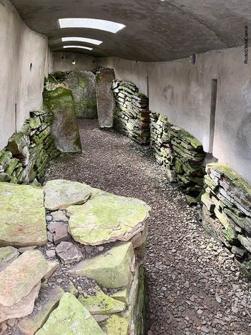
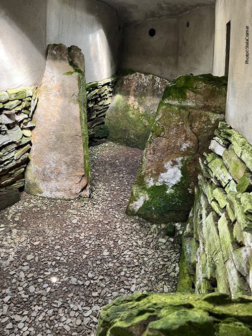
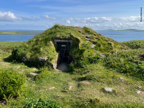


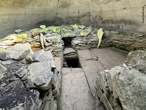
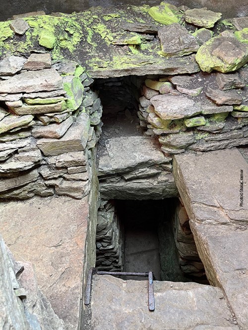
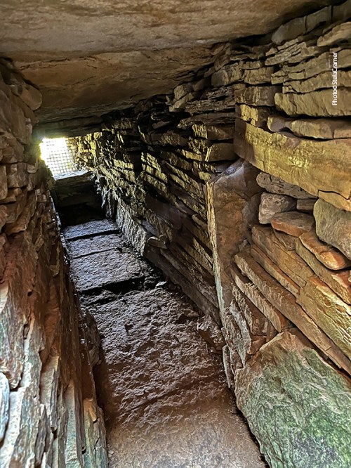

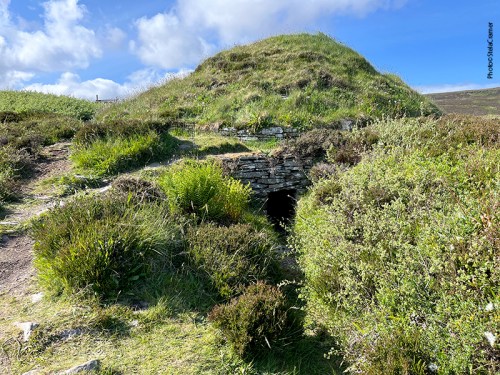
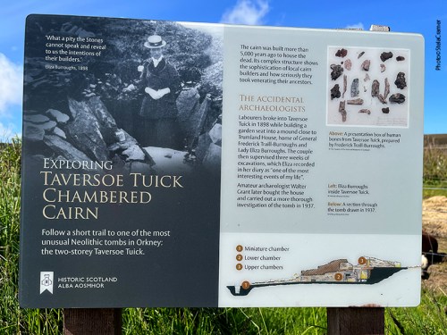
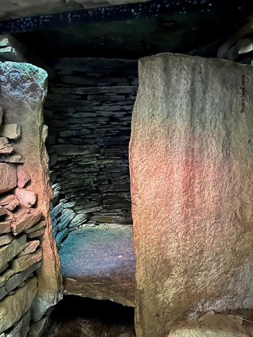
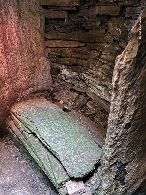
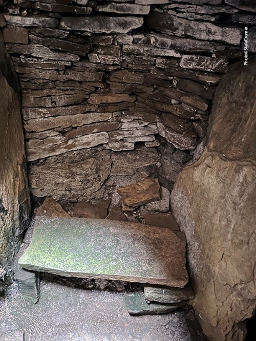
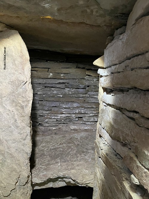
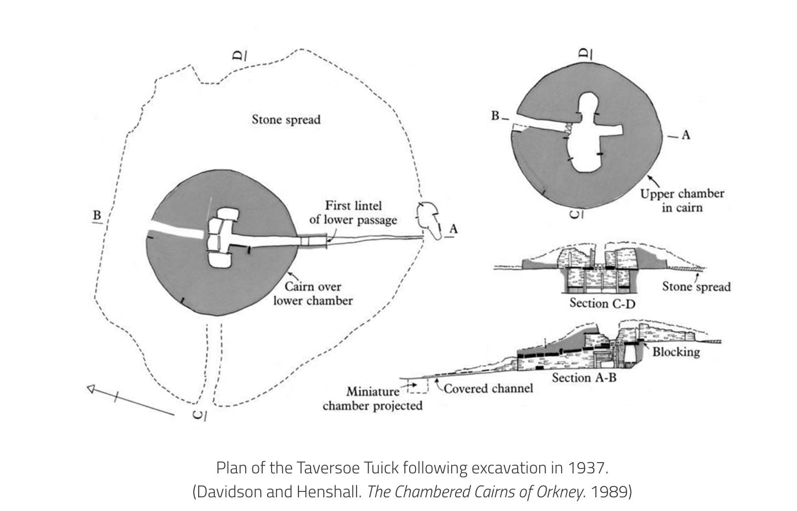

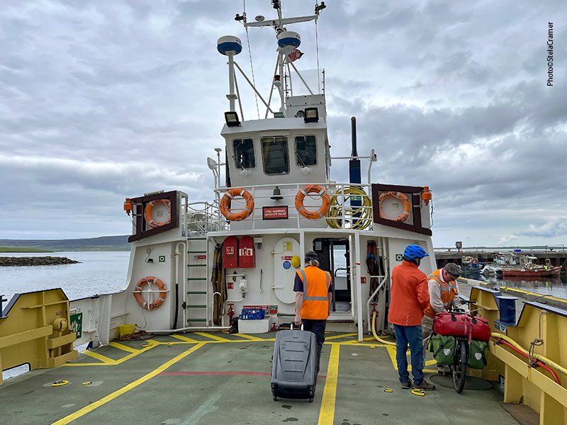
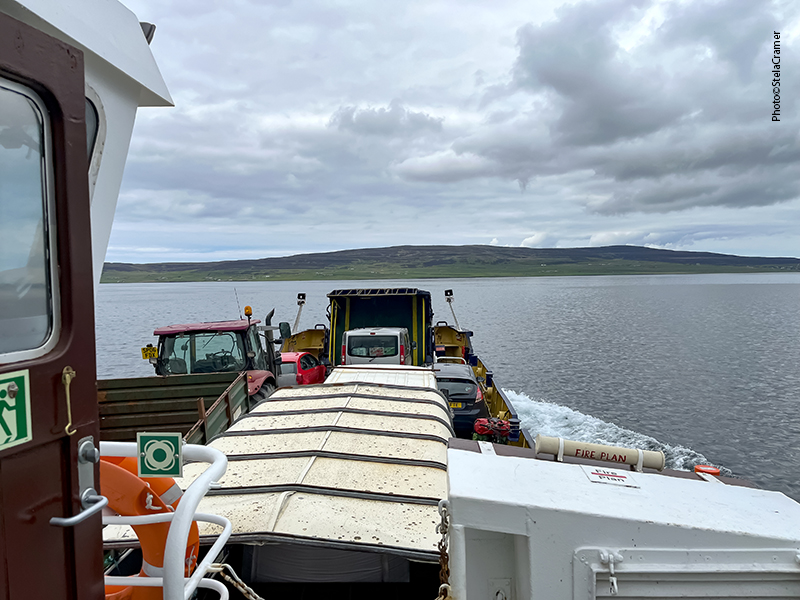
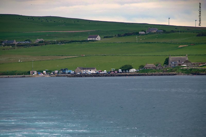


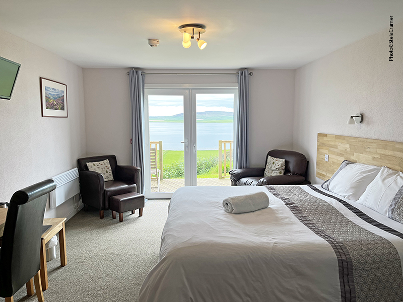


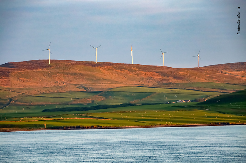
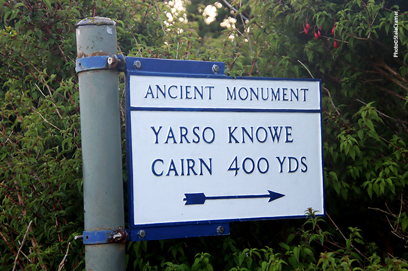


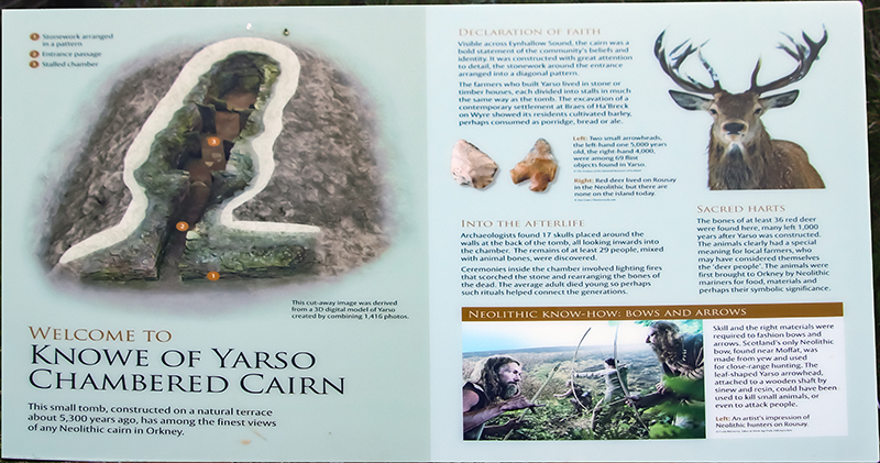


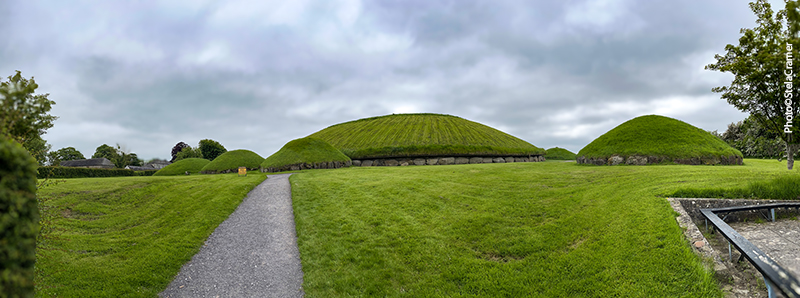

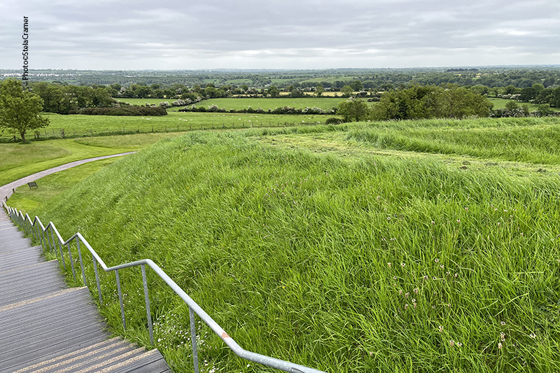


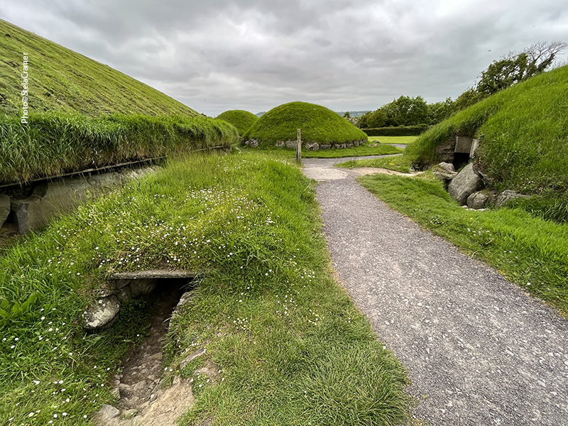

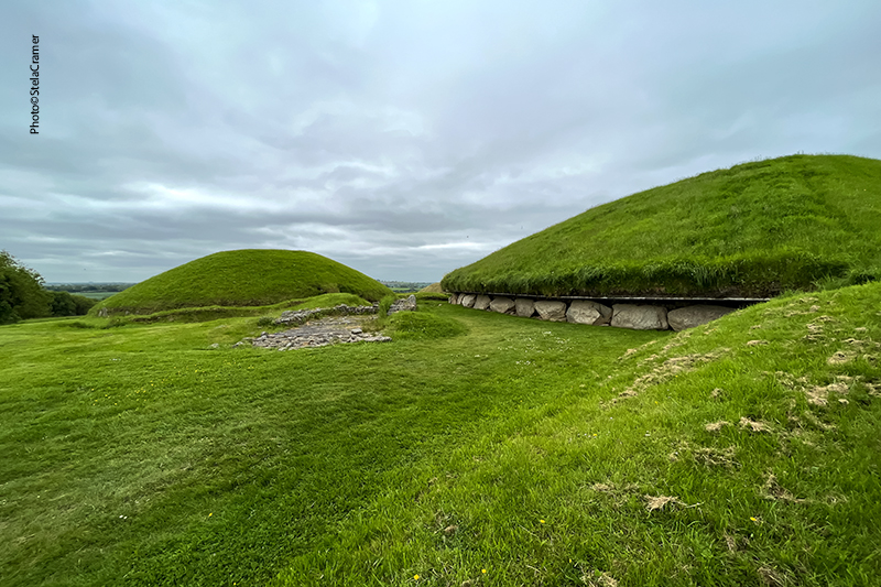


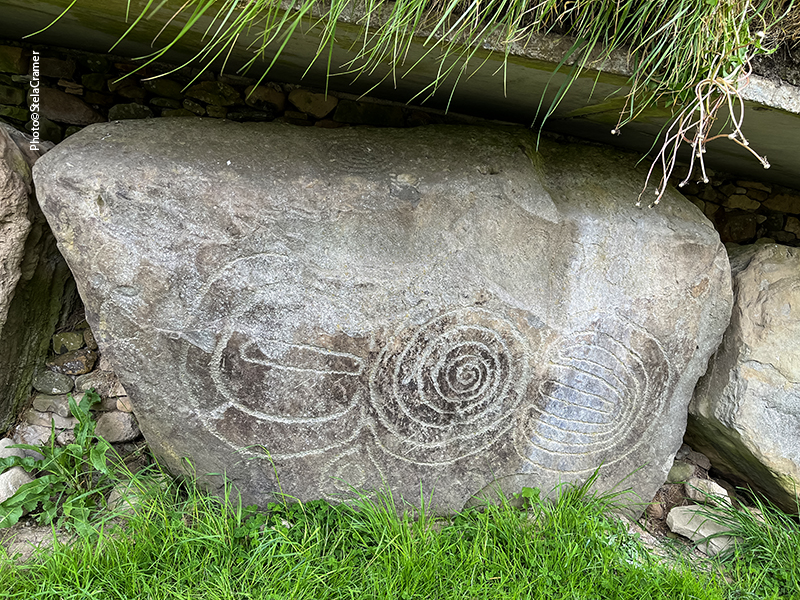


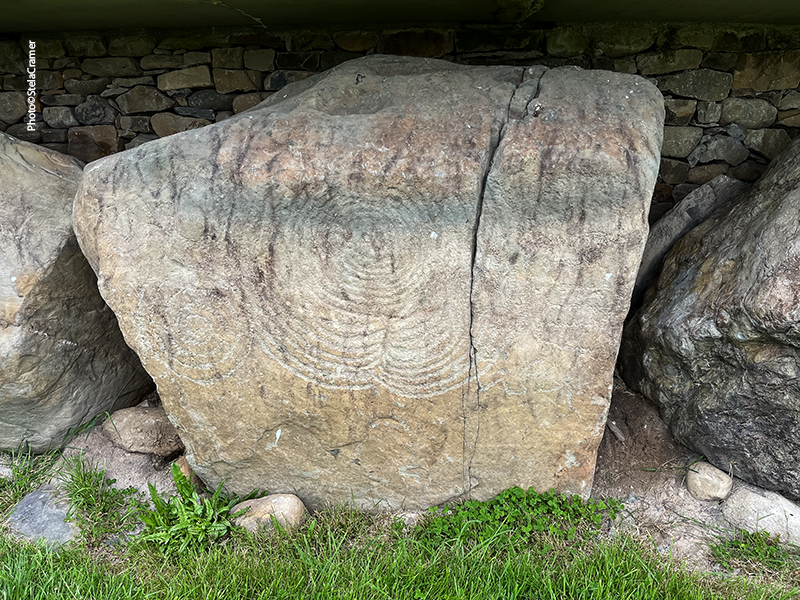


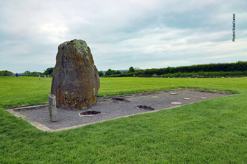

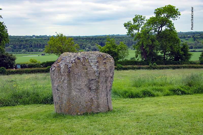


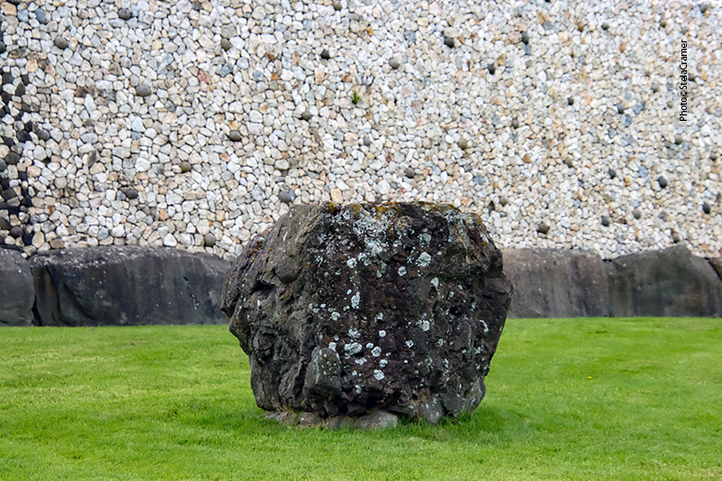

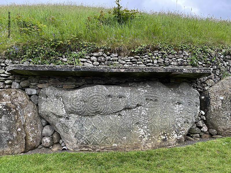
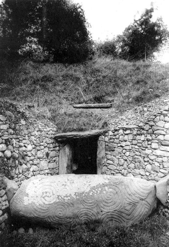
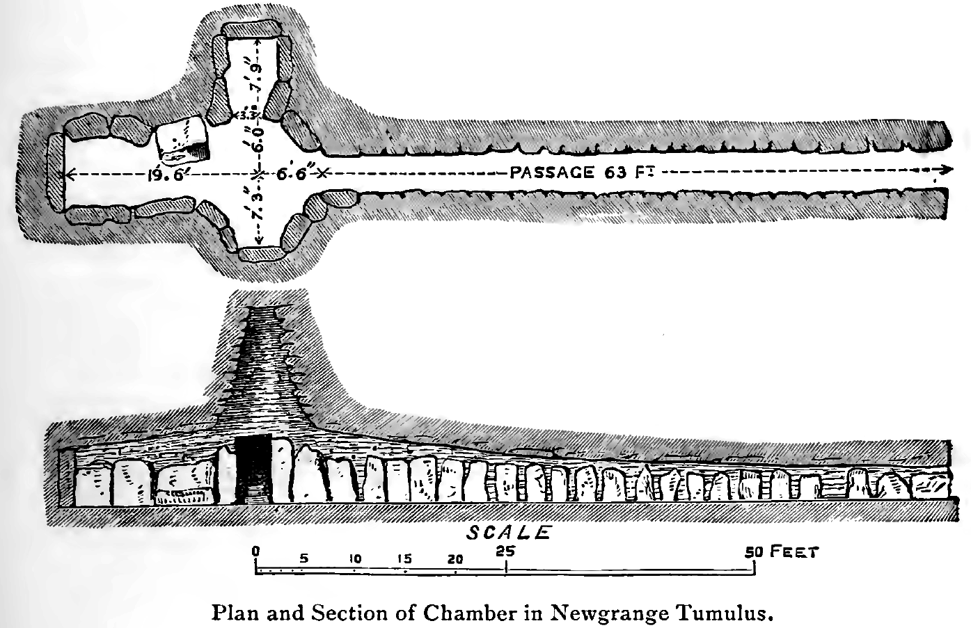
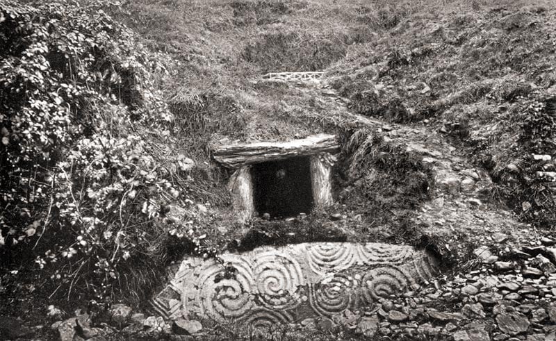


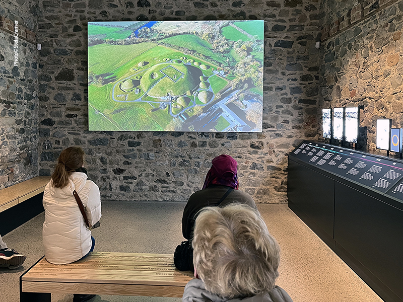
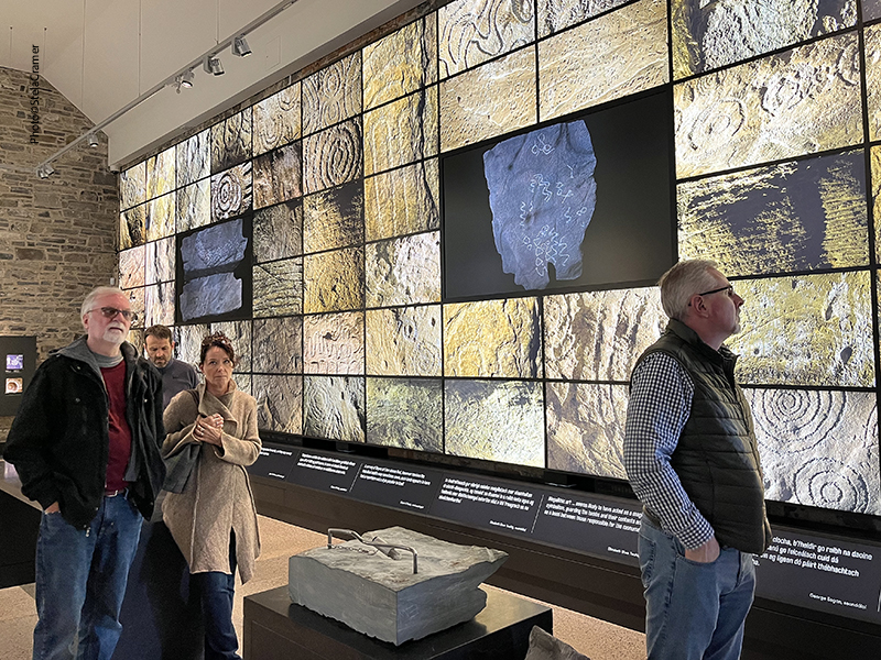
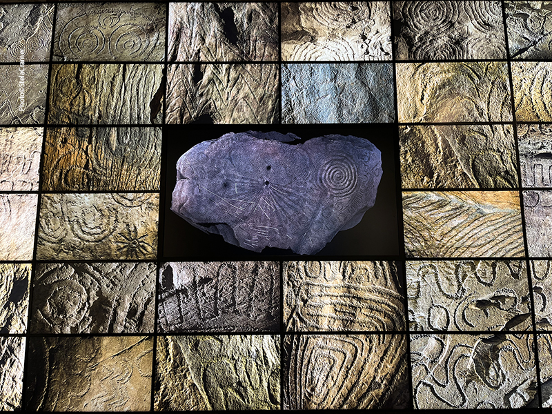


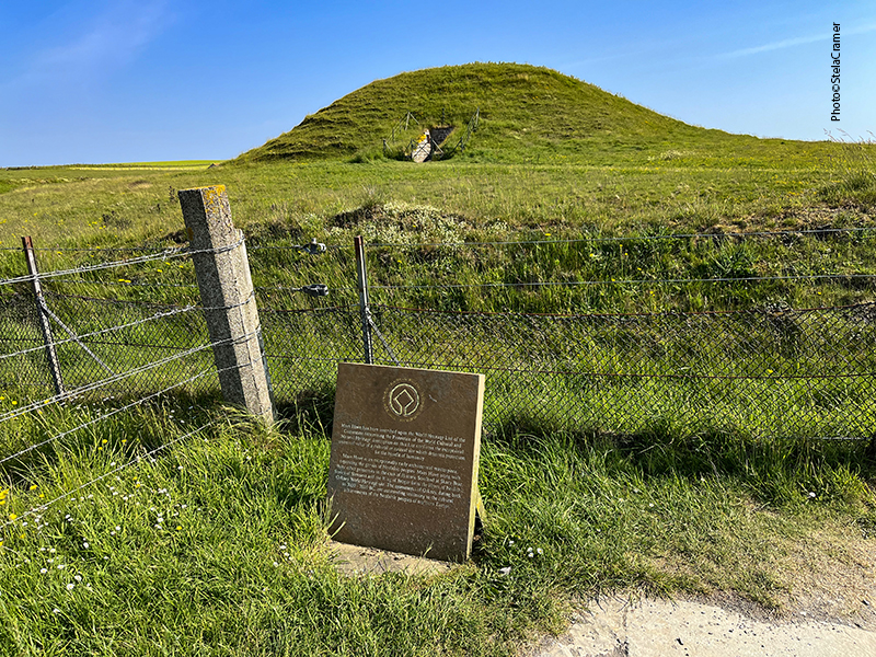


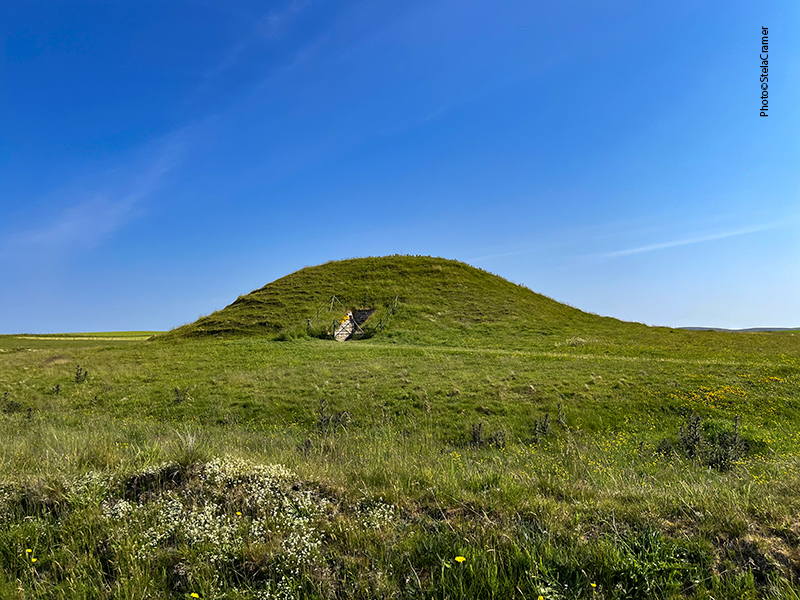


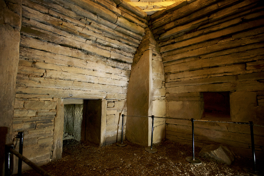
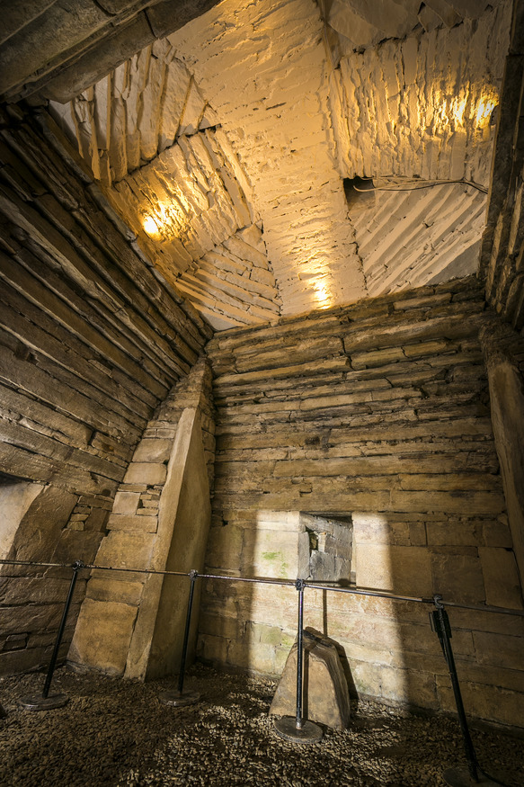
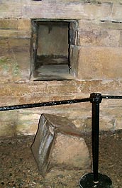
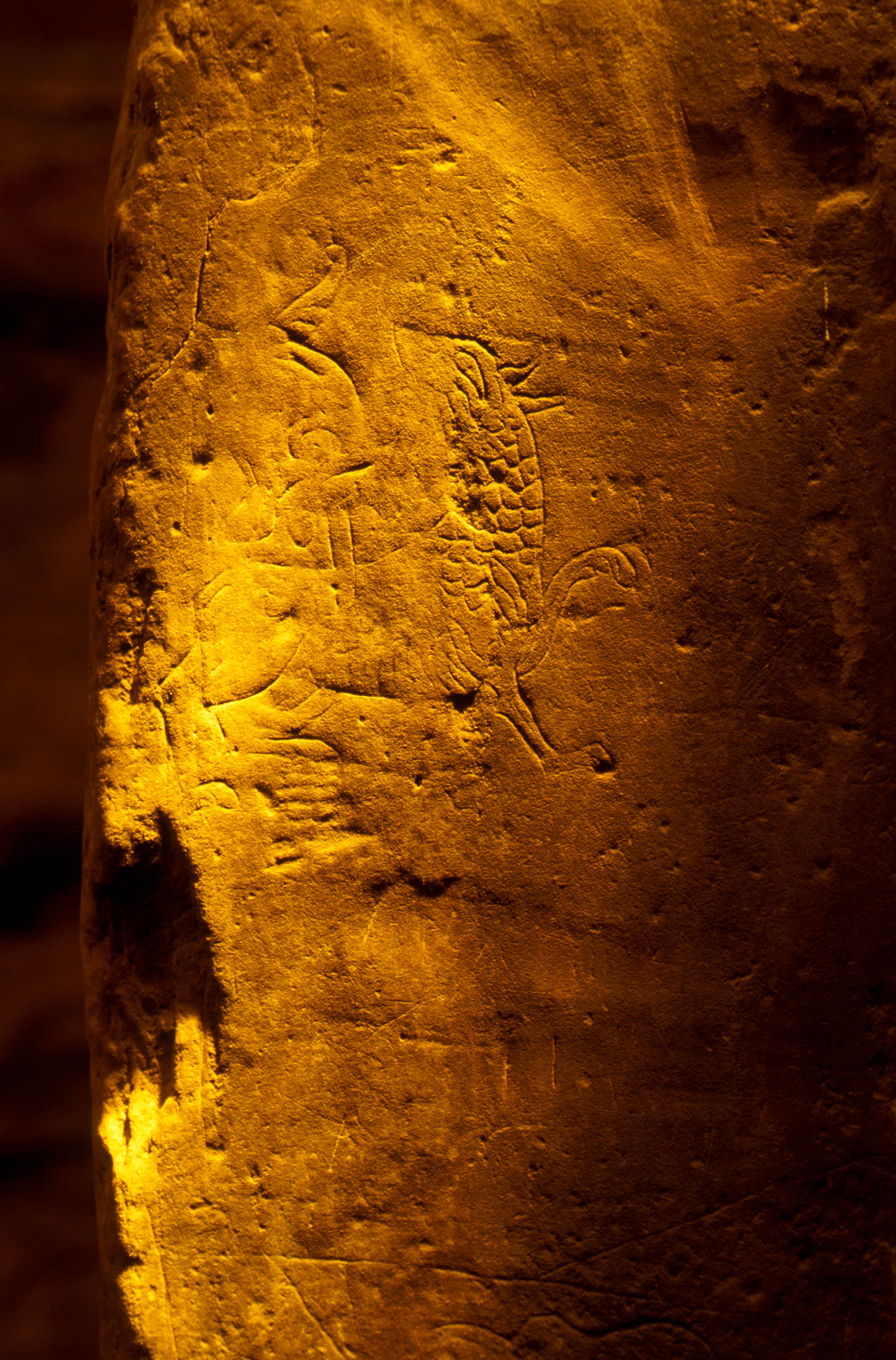
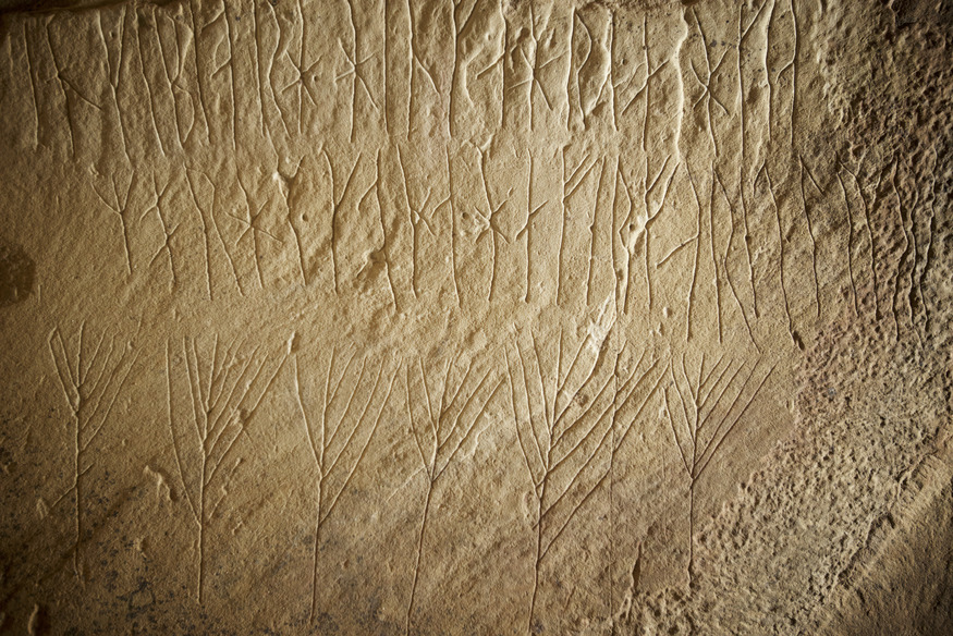


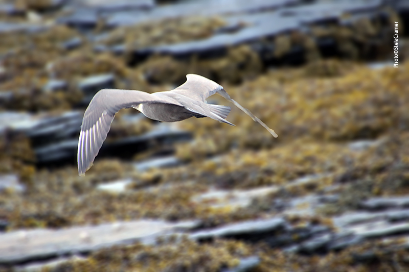
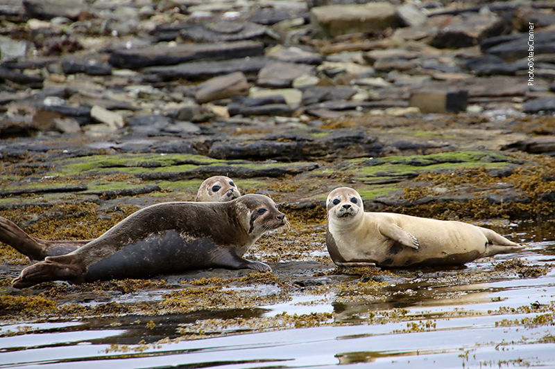

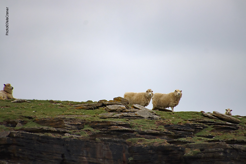


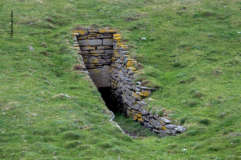
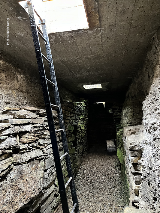
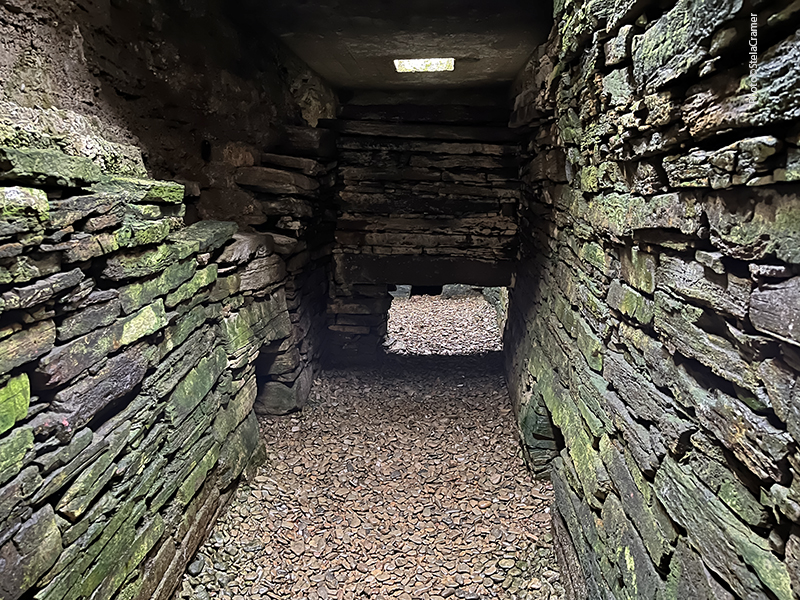


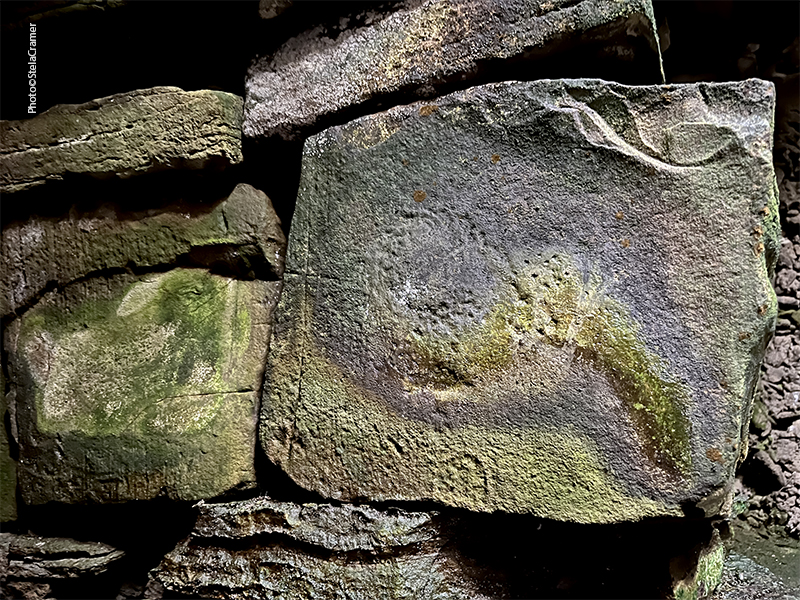


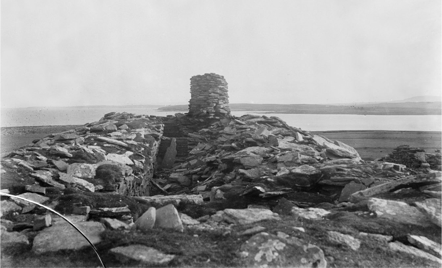

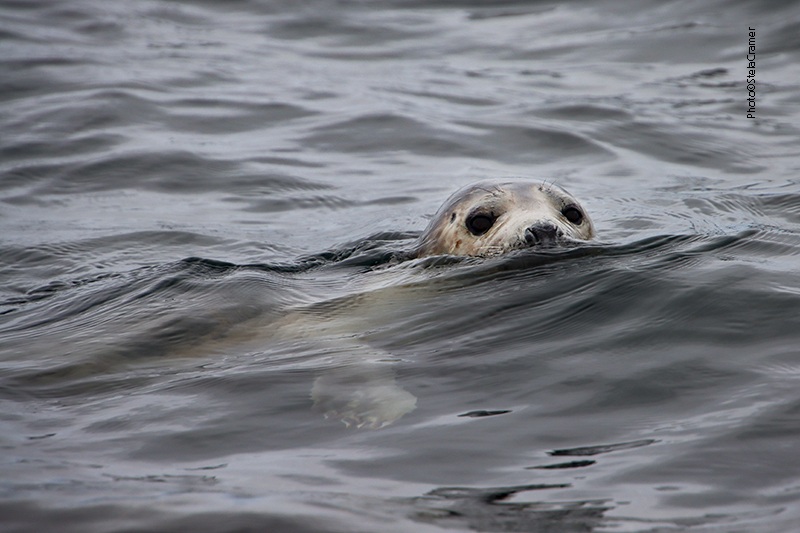
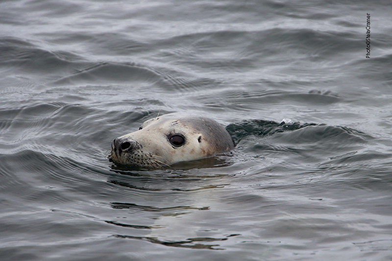


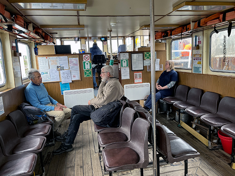
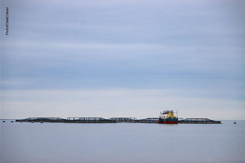

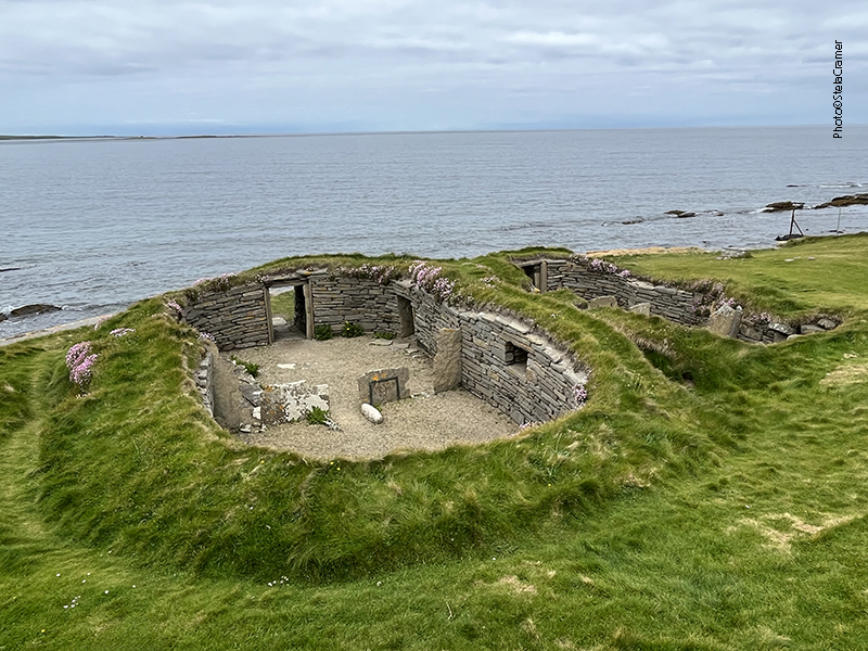

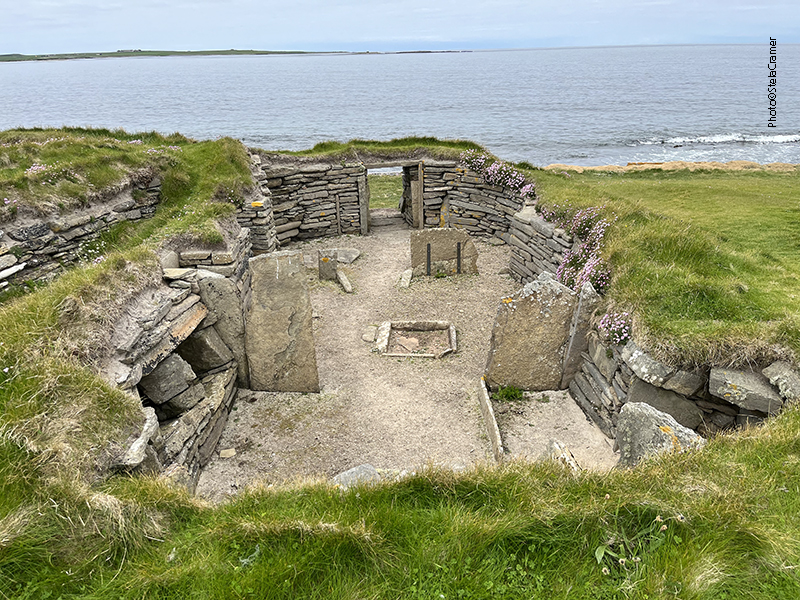

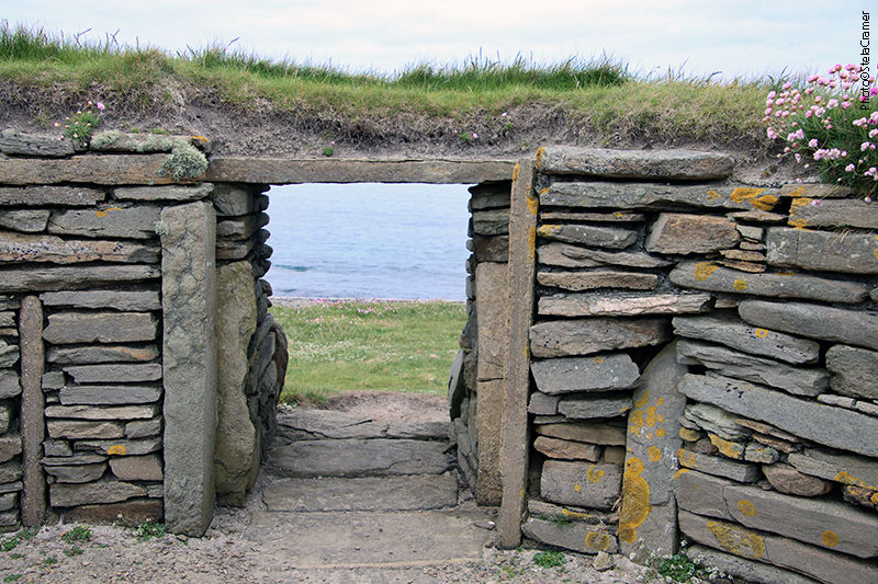

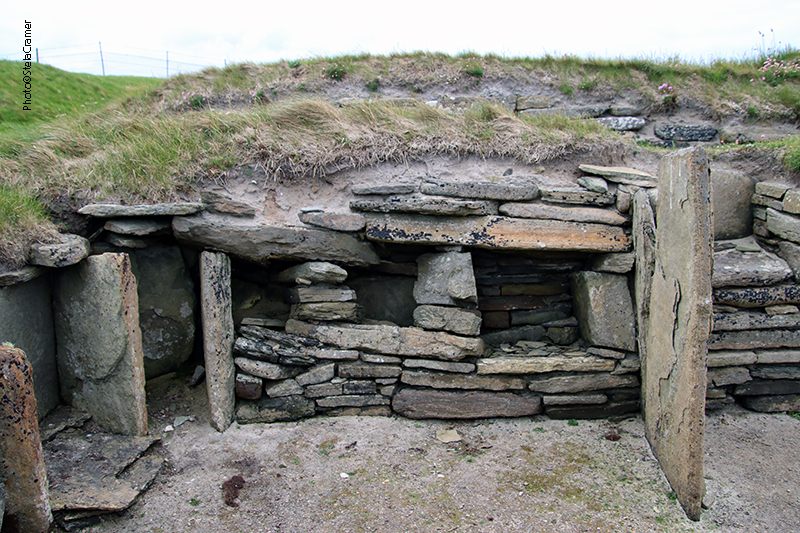
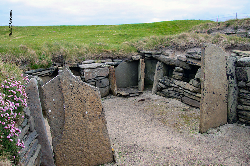
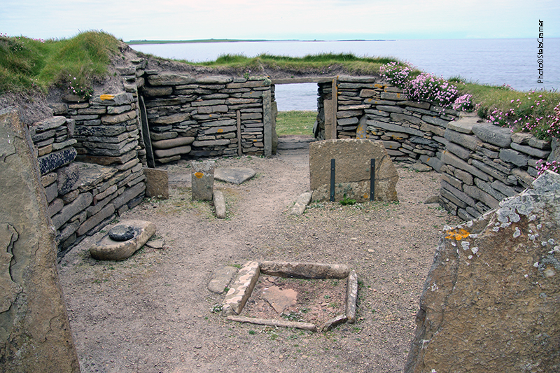


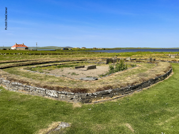

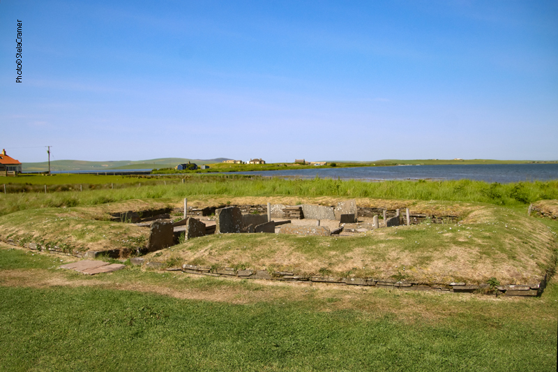


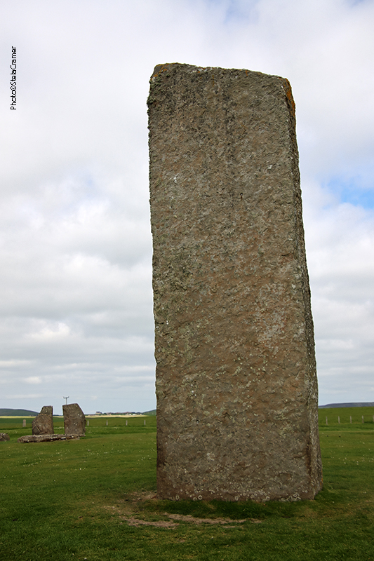
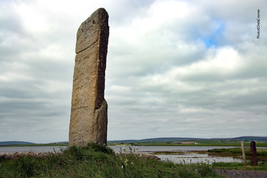


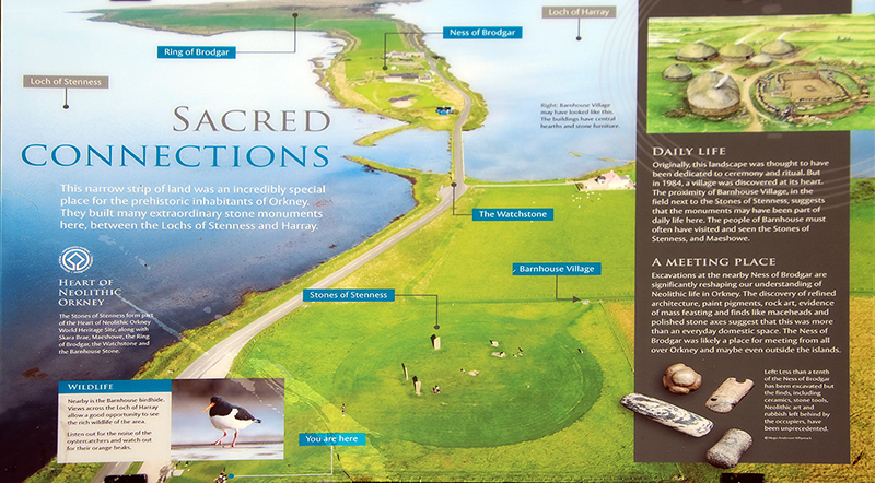
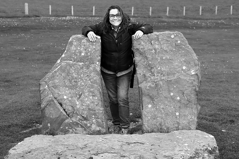


