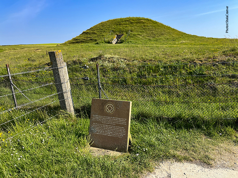
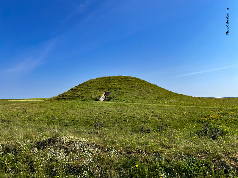
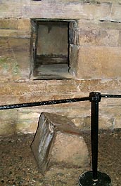
Voltando ao Coração Neolítico de Orkney, chegamos a Maeshowe ( pronuncia-se Máesrráue), uma das maiores “tumbas compartimentadas” (Chambered Cairns), e com a estrutura mais sofisticada. Construído há cerca de 5000 anos atrás, o monumento marca o meio do inverno: por 3 semanas antes e depois do Solstício de Inverno (21 de Dezembro, o dia mais curto do ano no Hemisfério Norte), o sol poente brilha através da passagem de entrada iluminando uma pequena câmara na parede do fundo.
Back to Neolithic Heart of Orkney, we’ll visit Maeshowe chambered tomb, the finest in north-west Europe: one of the largest and most sophisticated in structure. Built around 5000 years ago, probably around 2800 BC, it marks the midwinter: for 3 weeks before and after the solstice (21 December, the shortest day of the year), the setting sun shines straight down the passageway into the tomb, illuminating the chamber at the back interior wall.

“Tumbas compartimentadas” como Maeshowe se caracterizam por uma passagem de entrada longa e baixa ( você não consegue entrar sem se abaixar) que leva a uma câmara principal, retangular ou quadrada, a partir da qual se pode acessar cubículos laterais. É o que se chama também de “ túmulo de passagem”, como Newgrange (na Irlanda), que veremos aqui a seguir. O alinhamento com o Solstício de Inverno, ou o de Verão, é uma característica desse tipo de construção. Mas em Maeshowe não foram encontrados restos humanos! Arqueólogos sugerem que o lugar era usado como observatório, calendário, ou mesmo para cerimônias, e não como túmulo… nunca saberemos ao certo.

Chambered tombs of the Maeshowe “type” are characterized by a long, low entrance passageway leading to a square or rectangular chamber from which there is access to a number of side cells.
It’s called a “passage grave”, just like Newgrange (in Ireland) that will be shown here next. Alignment with aspects of the winter or summer solstice is a typical feature of such buildings. But no evidence of human remains had been found at this site! Archaeologists suggest that it was used as an observatory, calendar, and for ceremonies rather than as a tomb…we will never know for sure.

O acesso ao interior é unicamente por tours guiados, que começam e terminam no Centro de Visitantes em Stenness, de onde saem os microônibus levando grupos de no máximo 16 pessoas até o monumento, até 7 vezes por dia. É proibido bater fotos no interior da câmara, e pedem que os visitantes não toquem em nada. Apesar disso, o próprio guia do meu tour a toda hora se encostava nas paredes durante sua explanação…
Access to Maeshowe Chambered Cairn is by guided tour only, starting and finishing at the Visitor Centre at Stenness. Tours depart from there on a shuttle bus which takes tour groups of 16 people down to the chambered cairn itself between 4 and 7 times a day. Visitors are not allowed to take photos inside the chamber, and advised to not touch anything, although our guide, himself, was always leaning on the walls while giving his speech.


O sol parece estar sentado em cima da pedra enquanto seus raios atingem o interior do monumento. / The Barnhouse Stone, standing in a field some distance from the tomb, is perfectly aligned between the entrance and the setting sun, that sits right above the standing stone as the sunlight penetrates the tomb.

The mound encasing the tomb is 115 feet in diameter and rises to a height of 24 feet. Surrounding the mound, at a distance of 50 feet to 70 feet is a ditch up to 45 feet wide. The grass mound hides a complex of passages and chambers built of carefully crafted slabs of flagstone weighing up to 30 tons.

Archaeologist James Farrer first excavated the cairn in 1861, having dug down through the top of the mound – a choice which has been eventually criticized – because originally the mound had a distinctly different shape than it has today. As in the illustration above, Maeshowe was once conical, with a deep depression in the top. It had a diameter of around 100 ft and stood 36 ft high.

/ In 1910 the site was taken under government care and a white painted brick roof was built over the Neolithic masonry (in part to close the cavity made by Farrer); a cap of concrete, covering the roof, was added and the mound shaped to its present form.
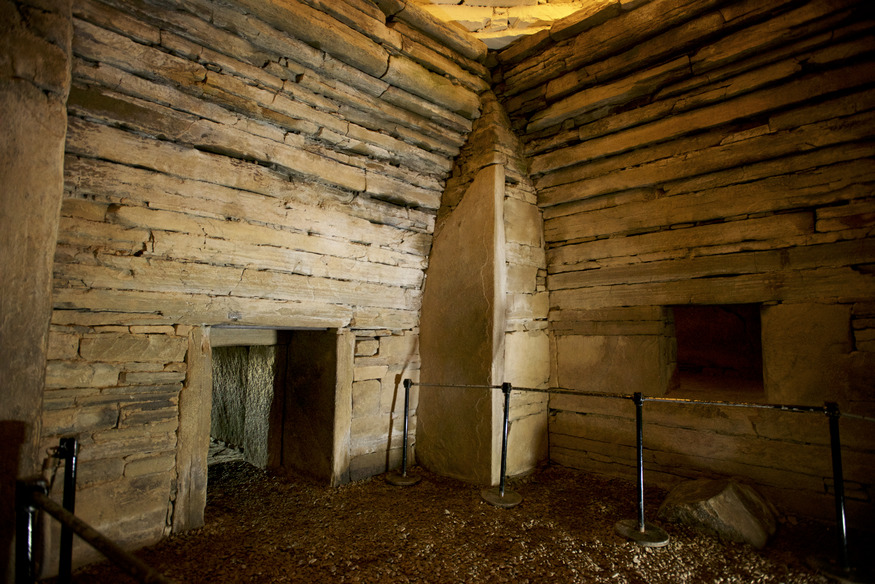
Pesquisas arqueológicas mais recentes sugerem que a estrutura foi construída por cima de uma mais antiga, talvez uma casa neolítica que posteriormente deu lugar a um círculo de pedras, das quais quatro teriam sido aproveitadas, formando os quatro cantos da câmara principal de Maeshowe. Estas pedras não tem aparentemente nenhum propósito arquitetônico: não apoiam o telhado, nem servem para reforçar a estrutura, portanto os construtores deviam ter outras razões para deixá-las ali.
Archaeological work in recent years hints that the cairn was built on top of an earlier structure – perhaps an early Neolithic house, later replaced by a stone circle – four of the stones of which came to be incorporated into Maeshowe, forming the corners of the main chamber. These stones serve no architectural purpose: don’t support the roof and in no way strengthen the structure, so the builders must have had other reasons for placing them here.
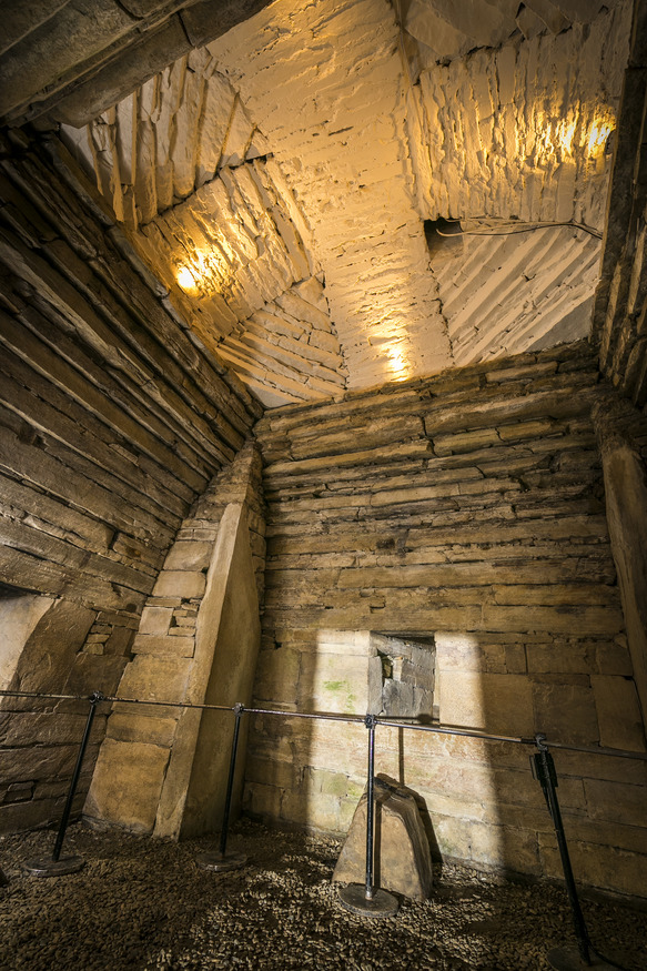
A câmara é basicamente construída por “fatias” de pedra, muitas das quais atravessam todo o comprimento das paredes. Em cada canto, eleva-se um enorme contraforte, formando um ângulo que vai até o teto. A partir de uma altura de 90cm as pedras que formam as paredes passam a ser sobrepostas de forma a ir arredondando, criando um teto em forma de colméia. Uma construção desse porte deve ter sido um tremendo desafio para nossos ancestrais, que não dispunham de ferramentas de metal ou máquinas. Podemos inferir também um elevado grau de empenho da sociedade.
The chamber is constructed largely of flat slabs of stone, many of which traverse nearly the entire length of the walls. In each corner lie huge angled buttresses that rise to the vaulting. At a height of about 3 feet (0.91 m), the wall’s construction changes from the use of flat to overlapping slabs creating a beehive-shaped vault. Creating such a huge building must have been a major challenge for our remote ancestors, working without metal tools or powered machinery. It also clearly shows a tremendous social commitment.
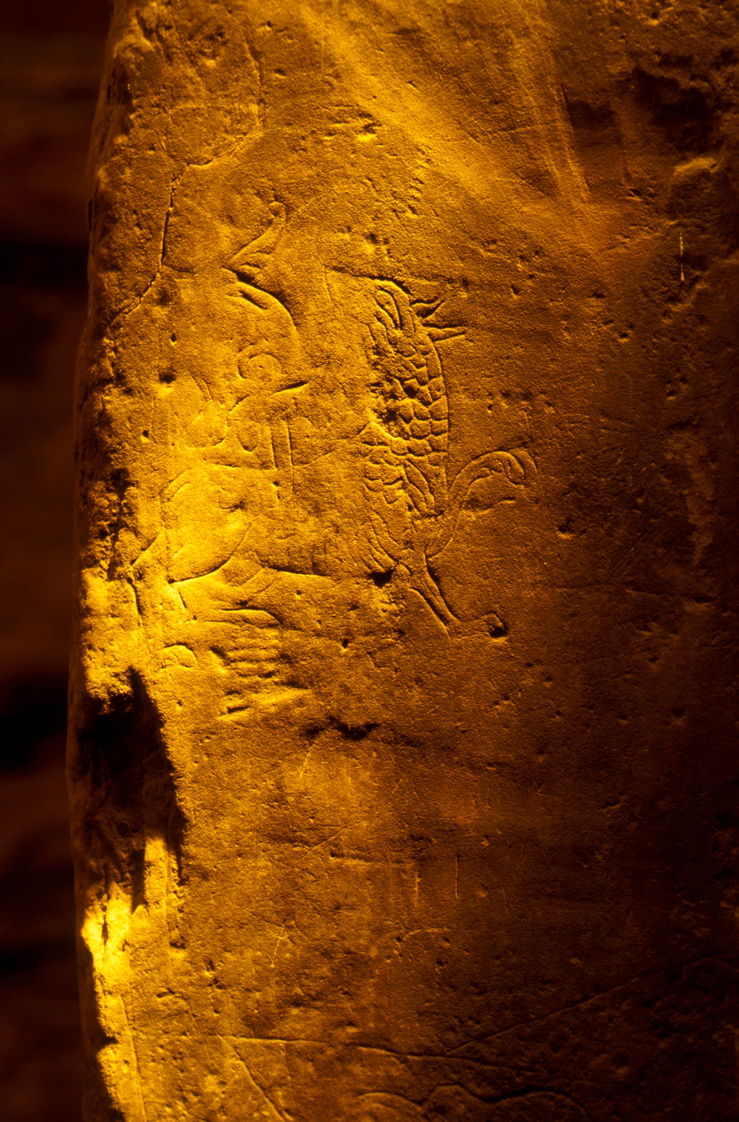
Mais de 30 inscrições rúnicas, assim como um dragão e outros animais foram encontradas entalhados nas paredes. Datam do séc. 12, atribuídas a um grupo de Nórdicos que entrou no monumento para abrigar-se de uma tempestade. Este grupo poderia ter levado quaisquer restos e/ou objetos de valor que ali houvesse: parte do grafite rúnico menciona um grande tesouro encontrado no local e outro enterrado ali perto. Não se encontrou nenhuma evidência disso, mas também não sabemos que tipo de coisa podia ser chamada de tesouro por uma civilização ancestral.
Embora seja basicamente equivalente a pichação, trata-se da maior coleção de tais inscrições no mundo. Fico pensando se daqui a 5.000 anos arqueólogos vão encontrar os nomes que pessoas gravam em monumentos (vandalismo, na verdade) e consagrá-los como arte ancestral.
One of Maeshowe highlights are the (more than thirty) runic inscriptions as well as the engraving of a dragon and other animals carved on the walls. These date to the 12th century when a band of Norsemen took refuge in the cairn during a winter storm. This same group may have carried off whatever valuables or remains were there, if such existed: some of the runic graffiti mentions a great treasure taken away from the site and another buried close by the site. No physical evidence was found to support such claim, but the word “treasure” could have easily meant something quite different to an ancient community than it does to us nowadays.
It represent the largest single collection of such carvings in the world, but most of the inscriptions are simply ancient graffiti. I wonder if in 5.000 years from now archaeologists will find people’s names carved in monuments ( actually vandalism…) and praise them as ancient artwork.
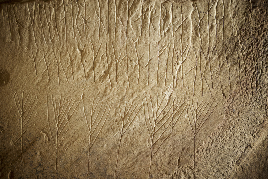
“Haermund Hardaxe gravou estas runas” / “Haermund Hardaxe carved these runes”
“Ottarfila gravou estas runas”/ “Ottarfila carved these runes”
“Benedikt fez esta cruz” / “Benedikt made this cross”
“Tryggr gravou estas runas”/ “Tryggr carved these runes”
“Arnfithr o filho de Stein gravou estas runas” / “Arnfithr the son of Stein carved these runes”
…e por aí vai. / …and on it goes

Acredito ter feito uma boa escolha nesta viagem: fiz um tour misto, parte sozinha e parte com um grupo pequeno, um tour que super recomendo, abrangendo as Orkneys e Shetlands. Na verdade cheguei em Orkney uma semana antes do grupo para visitar lugares que não constavam do programa da excursão, como Westray, Papay e Rousay. Quando o grupo chegou, as visitas a sítios como Skara Brae e Maeshowe, que envolviam compra de ingresso, já estavam incluídas no pacote. Talvez eu sozinha não tivesse conseguido entradas nos dias convenientes, pois a quantidade de turistas era surreal. Três navios de cruzeiro gigantes estavam atracados em Kirkwall ao mesmo tempo . Tudo estava lotado, inclusive hotéis. Meus pernoites “solo” tinham sido agendados com 3 meses de antecedência, inclusive com tarifas melhores. E depois de semanas viajando sozinha, foi bom passar dias com outras pessoas, excelentes guias, sem preocupação com transporte. Deixo abaixo o link da agência e um filminho mostrando o interior de Maeshowe, que era proibido fotografar.
I believe I made a solid choice for this trip: a mixed tour, part alone and part in a “Orkney- Shetland small guided group”, which I strongly recommend. I arrived in Orkney one week before the group, to visit places that were not in the tour program, such as Westray, Papay and Rousay. After joining the group, I didn’t have to worry about buying tickets to sites like Skara Brae and Maeshowe, because it was included in my package. By myself, perhaps it would be difficult to get the tickets in a schedule of my choice, because the place was surreal, crowded with tourists – 3 huge cruise ships were docked at once in Kirkwall. There were no vacancies in hotels and B&Bs; fortunately I had my solo bookings all done 3 months in advance, actually with better prices. Besides, after travelling alone for weeks, it was good to spend days with other people, outstanding guides and no worries about transport.
I leave you with the tour agency link and a short movie on Maeshowe interior, where taking pictures was forbidden.