Feeds:
Posts
Comentários

Archive for setembro \25\America/Sao_Paulo 2023


Skara Brae já era habitado antes da construção das pirâmides do Egito e Stonehenge /
Skara Brae was inhabited before the Egyptian pyramids and Stonehenge were built

A aldeia Neolítica de Skara Brae foi descoberta no inverno de 1850 quando uma tempestade carregou a grama e areia de dunas junto à Baía de Skaill, expondo as ruínas de construções de pedra. Skara Brae é considerada, até os dias de hoje, a mais bem preservada aldeia Neolítica no Norte da Europa – não apenas pela antiguidade, mas especialmente pelo grau de preservação. As estruturas das casas e o mobiliário, enterrados na areia, se mantiveram em condições impressionantes. Em nenhum outro lugar no norte da Europa foi encontrado testemunho tão rico da vida desses povos ancestrais.

Bay of Skaill

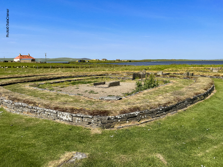
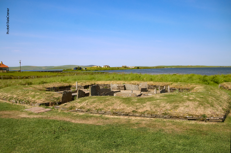
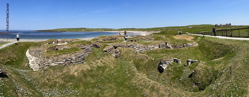
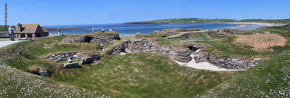
The Neolithic village of Skara Brae was discovered in the winter of 1850. Wild storms ripped the grass from a high dune beside the Bay of Skaill, and exposed an immense midden (refuse heap) and the ruins of ancient stone buildings. The discovery proved to be the best-preserved Neolithic village in northern Europe. And so it remains today. Skara Brae is remarkable because of its age, and even more so for the quality of its preservation. Its structures, buried in sand, survived in impressive condition – as did, incredibly, the furniture in the village houses. Nowhere else in Western Europe can we see such rich evidence of how our remote ancestors actually lived.

Arqueólogos acreditam que a aldeia ficava bem mais longe do mar, junto a um pequeno lago. Depois de séculos de erosão, agora se encontra bem na orla da Baía de Skaill, e não se sabe o tamanho original da aldeia, nem a extensão destruída pelo mar. Apesar do muro de proteção que foi construído, o sítio ainda é bastante vulnerável à elevação do nível do mar, fortes chuvas e tempestades.

Archaeologists believe it was originally built next to a small loch, farther from the sea than it is today. After centuries of erosion, Skara Brae now stands right by the shore of the Bay o’ Skaill and we don’t know how large the settlement was nor how much of it has been lost to the sea. The site is now protected by a seawall, but it’s still extremely vulnerable to rising sea levels, increased rainfall and severe storms.

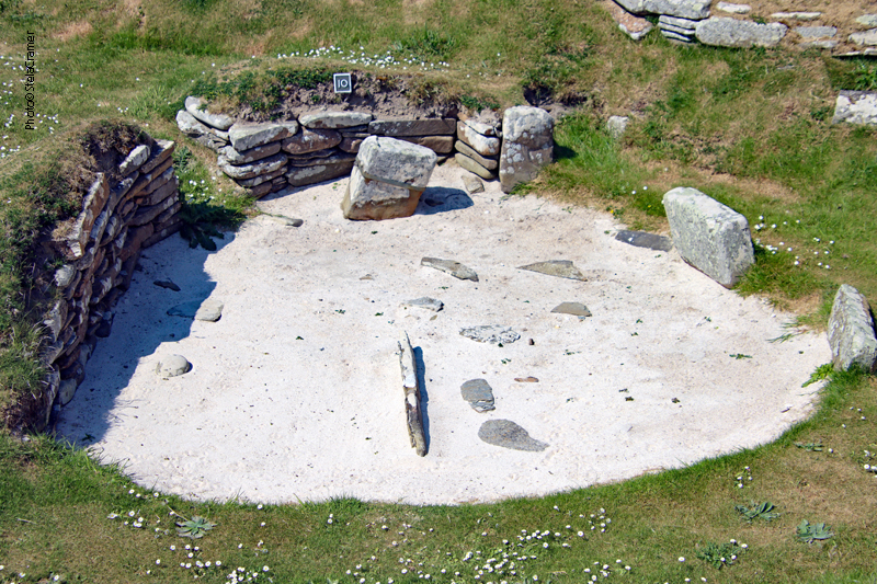
A aldeia é formada por habitações de apenas um cômodo, medindo aproximadamente 40 m2, retangulares com os cantos arredondados, e apenas uma entrada estreita, que podia ser fechada com um bloco de pedra – a mesma “flagstone” da qual todas as casas eram construídas. As unidades eram interligadas por passagens que vieram a ser cobertas ao longo do tempo, trazendo mais estabilidade e isolamento térmico, tipo um abrigo subterrâneo, super necessário no rigoroso inverno de Orkney.

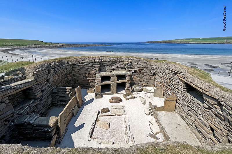
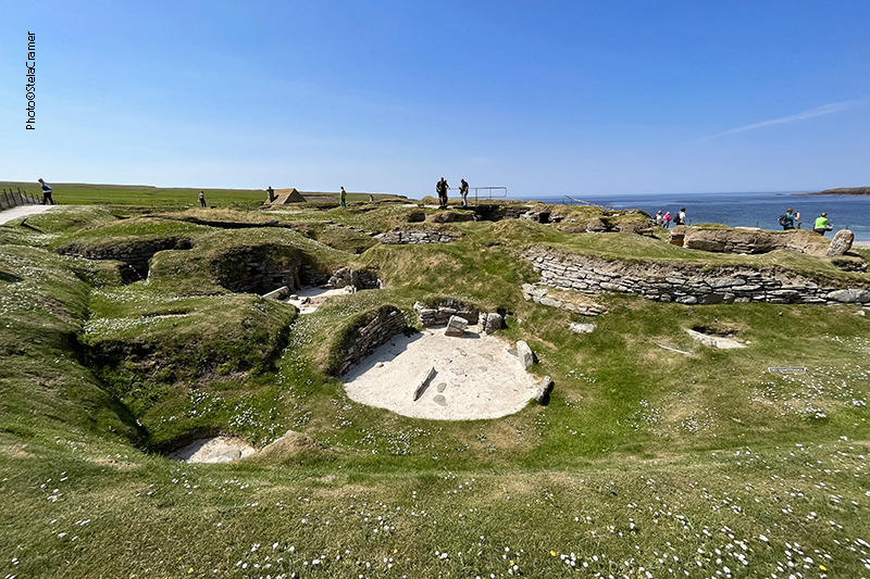
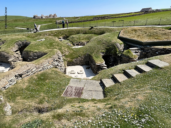
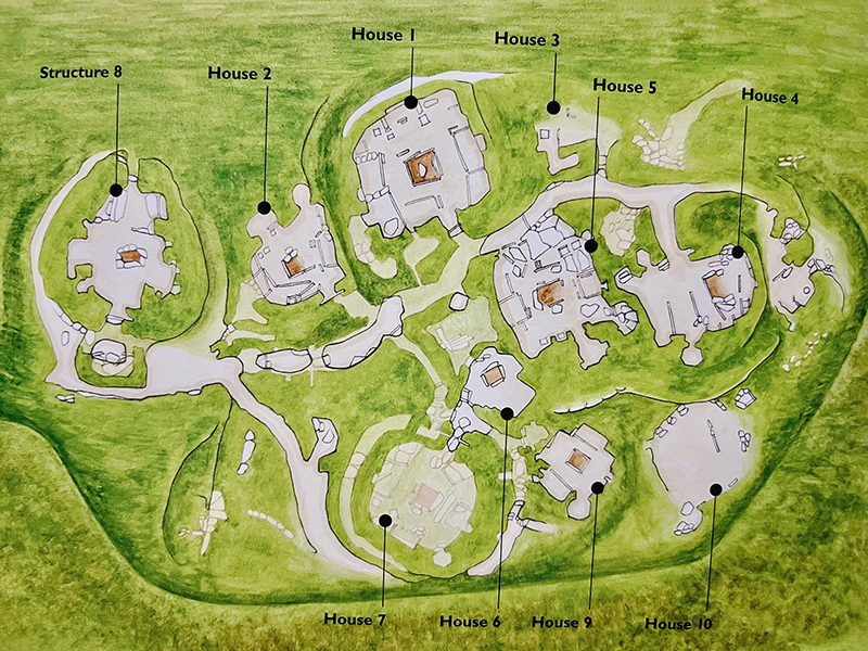
The village consisted of several one-room dwellings, each 40 square metres (430 sq ft) average rectangle with rounded corners, entered through a low, narrow doorway that could be closed by a stone slab. All houses are well-built of closely-fitting stone slabs. They were set into large mounds of midden (household refuse) and linked by passages. Research shows that the passages were covered at some point, providing the houses with more stability and insulation against Orkney’s harsh winter climate (earth-sheltering).

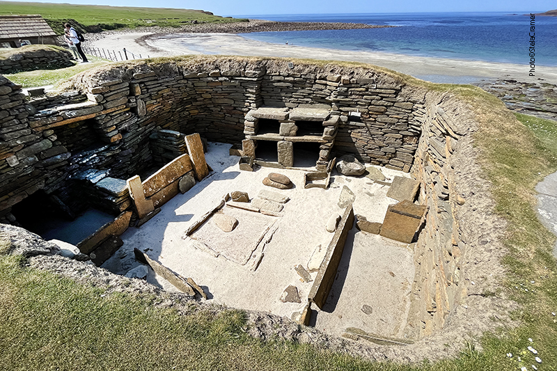
A mobília toda em alvenaria consiste numa “estante” em frente a uma lareira central para cozinhar alimentos e aquecimento; duas camas caixote, assentos, caixas de armazenagem e pequenos “tanques” pelo chão, onde talvez armazenassem iscas para pesca. Algumas casas apresentam um sistema de esgoto primitivo com “vasos sanitários” : uma pequena ante-câmara, parcialmente coberta, com água e drenagem. Os encanamentos de todas as casas se conectavam num sistema de esgoto que escoava a sujeira para fora da aldeia.

The ‘fitted’ stone furniture within each room comprised a “cupboard” in front of a hearth centrally placed for heating and cooking, two box beds, seats, storage boxes and small tanks set into the floor, perhaps for preparing fish bait. A number of dwellings offered a small connected antechamber, with access to a partially covered stone drain, with water used to flush the waste away. The drains from the individual huts emptied into a sewer system which connected the entire village.

Ossos encontrados no local mostram que os habitantes comiam principalmente carne de gado e ovelha. Caçavam também cervos e javalis. As peles de todos esses animais eram aproveitadas. Consumiam peixes, crustáceos e carne de foca, assim como ovos de aves marinhas, e também as próprias aves. Cultivavam cevada e trigo nos campos próximos. Para fazer fogo usavam estrume e algas marinhas secas e, talvez, madeira trazida pela correnteza, embora madeira fosse algo muito valioso para ser usado como combustível – praticamente não há árvores em Orkney.

Bones found in the place show that cattle and sheep formed the main part of the Skara Brae diet. Deer and boar were also hunted for their meat and skins. Fish, shellfish and seal meat were consumed and people probably collected the eggs of seabirds as well as the birds themselves. Barley and wheat were grown in the surrounding fields. Animal dung and dried seaweed were burned in their hearths and perhaps driftwood too, although that was a valuable asset to be used as fuel, because trees are practically non-exhistant in Orkney.

Escavações trouxeram à luz uma enorme variedade de artefatos, feitos de ossos (de animais, peixes, aves e mesmo baleia), marfim de baleia e de morsa, dentes de orca. Eram dados, miçangas, ferramentas (facas, agulhas, pás, enxadas); cerâmica e jóias – colares, pendentes e alfinetes de marfim de até 25cm. Destacam-se objetos de pedra ricamente entalhados. Os habitantes de Skara Brae eram fazendeiros, caçadores e pescadores capazes de, com ferramentas toscas e tecnologia rudimentar, fazer objetos belos e sofisticados.

A rich array of artefacts – made of animal, fish, bird, and whalebone, whale and walrus ivory, and orca teeth – has been discovered during the various archaeological excavations: gaming dice, hand tools like awls, needles, knives, beads, adzes, shovels; pottery and jewellery including necklaces, beads, pendants and ivory pins up to 9.8 in long. Most remarkable are the richly carved stone objects.These villagers were farmers, hunters and fishermen, capable of producing items of beauty and sophistication with rudimentary technology.

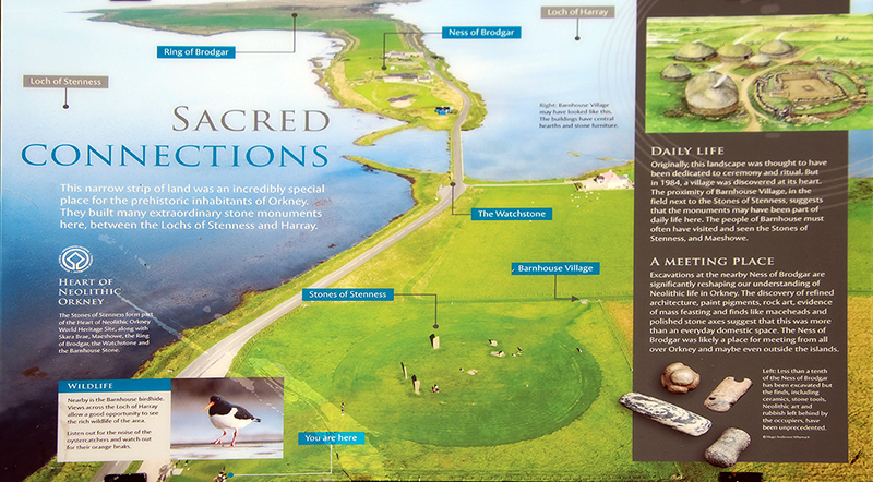
Skara Brae foi habitado durante 600 anos, coincidindo com a época em que os demais monumentos que formam o Coração Neolítico de Orkney foram construídos e estiveram em uso. As casas na aldeia foram construídas, reformadas e reconstruídas até 2500 AC, quando o clima ficou muito mais frio e úmido, possível razão para o abandono do local.

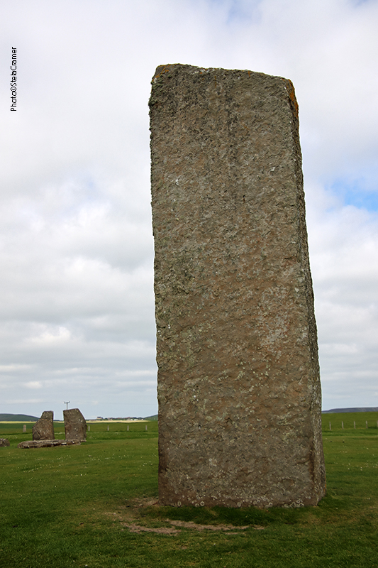
The site was continuously occupied for around 600 years (from 3180 BC to about 2500 BC), around the time the other four sites making up “The Heart of Neolithic Orkney” were built and in use. Houses were built, altered, replaced by new structures until around 2500 BC, when the climate changed, becoming much colder and wetter, so the settlement have possibly been abandoned by its inhabitants for this reason.

Aerial view of Skara Brae in Orkney – photo © Copyright Charles Tait
Mapa do sítio / Site map
Junto ao Centro de Visitantes foi construída uma réplica do interior de uma dessas habitações, onde as pessoas podem entrar, já que em Skara Brae os visitantes tem que se manter na trilha construída em volta do sítio.
Next to the Visitor Centre, a replica construction allows people to visit the interior of one of those prehistoric houses. In Skara Brae visitors must keep to the trail built around the site.
Café no Centro de Visitantes. Mais de 100.000 pessoas visitam skara Brae anualmente. /
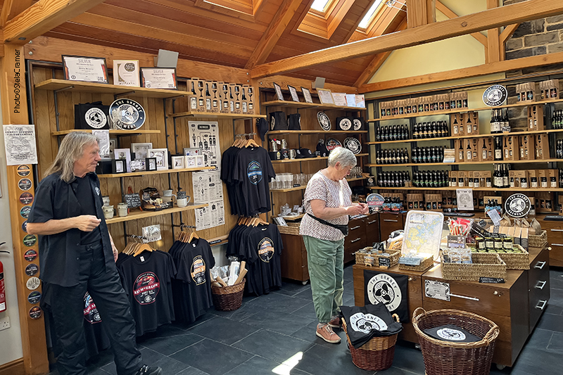
Cafe at Visitor’s Centre. Skara Brae greets more than 100.000 visitors/ year.
Loja de souvenirs no Centro de Visitantes. Cervejas artesanais locais fazendo sucesso! / Souvenir Shop at Visitor’s Centre, featuring local Craft Beers

Read Full Post »


Barnhouse Village atualmente é uma reconstrução das fundações de apenas quatro das habitações originais. A aldeia remonta a 3000AC./ Barnhouse today is a modern reconstruction of the foundations of just four of the original buildings.The settlement dates back to circa 3000 BC.

Este sítio foi descoberto e escavado pela primeira vez em 1984, pelo arqueólogo Colin Richard. Embora esteja a cerca de cem metros do círculo de pedras de Stenness, muitos visitantes nem o percebem. Há milhares de anos atrás tratava-se de um pequeno grupo de casas bem semelhantes às de Skara Brae, com lareiras, drenagem, camas e mobília em pedra. Os objetos ali encontrados ( cerâmica, ferramentas de pedra e sílex) também são similares.

Mapa de Barnhouse Village / Site map

This Neolithic site was was discovered and first excavated by archaeologist Colin Richard in 1984 and is often overlooked, but it’s only a little more than one hundred metres away from the Stenness stone circle. Thousands of years ago it would have been a small group of homes, some similar to Skara Brae, with their own hearths, box beds, internal drains and stone furniture. The objects found in there (pottery of the grooved ware, flint and stone tools) are similar as well.

Na entrada da Estrutura 8 há um curioso arranjo estilo varanda com uma lareira; existe outra lareira no meio da estrutura, do mesmo tamanho e formato da que se encontra no centro do círculo de Stenness/ Structure 8 has an unusual porch arrangement with a fireplace at the entrance, and another hearth inside, identical in shape and size to the hearth at the centre of the Stenness Stones.

Escavações realizadas entre 1986 e 1991 revelaram as bases de pelo menos 15 residências. A presença desta aldeia bem no meio do que se julgava ser um local cerimonial (Brodgar, Stenness) mostrou que tais monumentos faziam parte da vida cotidiana, ao contrário do que acreditavam os arqueólogos, que os consideravam construções isoladas. Por isso, a descoberta de Barnhouse Village foi um dos mais importantes achados arqueológicos do Reino Unido no século 20.

A chamada Estrutura 8, com lareira ao centro / Structure 8, with central hearth

Excavations conducted between 1986 and 1991 revealed the base courses of at least 15 houses. The discovery of this residential settlement changed archaeologists’s understanding of this landscape. Its presence at the heart of what was previously considered a ceremonial landscape ( Brodgar, Stenness) showed that these monuments were not set apart from daily life, but an integral part of it. That’s why Barnhouse Village was one of the most important archaeological finds in Britain in the 20th century.

A Casa nº3, uma das primeiras construídas em Barnhouse, apresenta semelhanças com as casas em Skara Brae, inclusive as caixas de pedras interpretadas como camas e prateleiras / House 3, one of the earliest dwellings at Barnhouse, shares features with the houses at Skara Brae, such as large stone boxes interpreted as beds and shelving.

No Neolítico, o Loch of Stenness era provavelmente um terreno pantanoso e não um lago. As pessoas que moraram em Barnhouse podem ter erigido as Pedras de Stenness. Podem ter conhecido pessoas que viviam em Skara Brae. Seria possível ir de uma aldeia a outra para assistir ou participar de alguma atividade e retornar no mesmo dia. Provavelmente existe mais arqueologia submersa no fundo dos lagos.

A Casa nº2, construída sobre uma plataforma de barro, apresenta um desenho complexo e paredes de alvenaria de alta qualidade. Embora a maioria das casas tenha passado por uma série de reconstruções, esta manteve sua forma original durante todo o período de ocupação da aldeia. / House 2, built on a clay platform, features a complex layout and walls of high-quality masonry. Although most houses here experienced many phases of rebuilding, this one mantained its original form throughout the site’s occupation.

In Neolithic times, the Loch of Stenness was probably a wetland area rather than a lake. The people who lived at Barnhouse may have raised the Stones of Stenness ; they could have known people who lived in Skara Brae. They would have been able to walk from one settlement to the other, watch or take part in some activity and walk home within a day. More archaeology is probably submerged beneath the lochs.

Objetos de sílex e pedra-pome encontrados na Casa nº 6 sugerem que o local fosse usado como oficina para trabalho em ossos, madeira e peles de animais / Many worked flints and pumice were found at House 6, suggesting that it may have been used for working of bone, wood and animal skins.

As estruturas eram feitas de “flagstone”, um tipo de rocha sedimentar abundante em Orkney. Esta pedra era ideal para construção com as ferramentas disponíveis no Neolítico, pois se dividia facilmente em “fatias” planas. Casas inteiras podiam ser construídas com essa pedra, que servia para pavimentação, cercas, paredes, pisos e mesmo telhados.

No Museu de Orkney, em Kirkwall, estão expostas pedras com inscrições encontradas em Barnhouse / Marked stones from Barnhouse Village are in display at the Orkney Museum, in Kirkwall.

The structures were made of flagstone, a sedimentary rock found abundantly throughout Orkney.
It’s easily split into flat stones and was therefore a good material for fine building work using Neolithic tools. Actually, whole houses were made of it: flagstone was used for paving slabs or walkways, patios, flooring, fences and even roofing.

Como poderia ser o povoado, com a Estrutura 8 em construção / Barnhouse Village as it may have looked with Structure 8 under construction

Entre Stenness/Aldeia de Barnhouse e o Anel de Brodgar encontra-se ainda outro site importantíssimo chamado Ness of Brodgar, em escavação. Até agora 25 estruturas foram descobertas, e chama a atenção dos pesquisadores a alta qualidade tanto da construção quanto dos artefatos encontrados. Infelizmente não pude visitar pois estava fechado, fora da temporada de escavação. Mas deixo aqui um link para o site oficial, onde você pode acessar modelos em 3D sob a aba “The Excavation”.

Between Stenness/Barnhouse and the Ring of Brodgar there’s another monumental site, the Ness of Brodgar, of monumental proportions. The ongoing excavation has brought to light so far 25 structures, impressive for the high quality of stonework and artefacts found. Unfortunately, out of the excavation season the site is closed, so I couldn’t visit it. But here is the link for its official site, where you can navigate in 3D models, under menu “The Excavation”:

https://www.nessofbrodgar.co.uk/

Read Full Post »


Standing Stones of Stenness: the oldest monument at the World Heritage Center./
O monumento mais antigo deste Patrimônio Mundial.

Escavações mostraram que este sítio era, originalmente, um círculo de pedras – possivelmente o mais antigo nas Ilhas Britânicas. Embora atualmente não exista mais o fosso ao redor das pedras – desgastado por séculos de lavoura – confirmaram que o mesmo tinha dois metros de profundidade, cercando uma área de 44m de diâmetro. Originalmente havia pelo menos 11 monolitos, dos quais restam apenas 4, e alguns cotocos.

Although the site today lacks the encircling ditch and bank, excavation has shown this site was a henge monument, possibly the oldest in the British Isles. In Neolithical times, the stone ring had been entirely surrounded by a ditch, two metres (6.5 ft) deep, surrounding an area 44 metres (144 ft) in diameter. Centuries of ploughing have almost entirely removed the henge which once enclosed the (at least 11) standing stones, of which only four survive today, and some stumps.

A Sentinela, às margens da lagoa (de água salgada) de Stenness. Do outro lado da estrada temos o lago de Harray, de água doce, o maior das Orkneys./ The Watchstone, by the shore of Loch of Stenness – a salt water (saline) lagoon. The freshwater Loch of Harray, on the other side of the road, is the largest loch of Mainland Orkney.

Em dezembro de 1814, um fazendeiro resolveu remover as pedras, pois lhe incomodava a quantidade de gente que invadia a propriedade para fazer rituais junto às pedras. Ele começou demolindo a Pedra de Odin, para ultraje geral. Quando, por fim, conseguiram fazê-lo parar, ele já tinha derrubado duas outras pedras.

A Pedra de Odin, à qual se atribuíam poderes mágicos, ficava ao norte do círculo. A pedra tinha um furo circular, através do qual casais tradicionalmente davam as mãos para assumir seu compromisso. Outras cerimônias eram realizadas ali, inclusive promessas e juramentos eram feitos pondo a mão na pedra – o chamado Voto de Odin.

Ilustração do sec.18 mostrando a Pedra de Odin e a Sentinela, no caminho para ao Anel de Brodgar. / A 18th-century illustration shows the lost Odin Stone and the Watchstone, by the road to the ring of Brodgar.

In December 1814 a tenant farmer in the vicinity of the stones, decided to remove them on the grounds that local people were trespassing and disturbing his land by using the stones in rituals. He started by smashing the Odin Stone. This caused outrage and he was eventually stopped, but two more stones had already been destroyed.

The Odin Stone, believed to have magical power, stood in the field to the north of the henge. It was pierced with a circular hole, and was used by local couples for plighting engagements by holding hands through the gap. Other ceremonies took place there, including the “Vow of Odin” – a tradition of making oaths or promises with one’s hand in the Odin Stone.

Na década de 70 a pedra que ficava sobre estas duas, como o tampo de uma mesa, foi retirada pois havia dúvida quanto à sua autenticidade. Os “pés” da mesa permanecem no lugar. / In the 1970s, a dolmen structure was toppled, since there were doubts as to its authenticity. The two upright stones remain in place.

Análise geológica dos monolitos revelou que cinco diferentes tipos de pedras foram utilizadas. Esta descoberta reforça a teoria de que, assim como em Brodgar, as pedras foram trazidas de diferentes lugares, provavelmente significativos, para a construção do monumento.
A construção de um círculo de pedras envolvia considerável esforço da comunidade, envolvendo atividades “especializadas” como planejamento, extração das pedras, transporte, construção de fundações e a construção final. Os círculos mais antigos no Reino Unido – Stenness e Callanish (este na Ilha de Lewis) – foram construídos alinhados com a posição do Sol e da Lua. Mas não há consenso entre os arqueólogos quanto à sua função. Poderiam ter sido locais cerimoniais, rituais, sociais, mortuários, para reuniões comunitárias…ninguém sabe ao certo. Eu acrescentaria pontos de comércio a essa lista de possibilidades.

Geological examinations of the surviving stones revealed that five different types of stone were used – a discovery that reinforces the theory that the stones for the monument, just like Brodgar, were brought to the site from various different, perhaps significant, locations.

A stone circle construction often involved considerable communal effort, including specialist tasks such as planning, quarrying, transportation, laying the foundation trenches, and final construction. The two oldest stone circles in Britain – Stenness and Callanish (this on the Isle of Lewis) – were constructed to align with solar and lunar positions. But no consensus exists among archaeologists regarding their intended function: places of ceremony, worship, burial grounds, social gathering places… nobody knows for sure. I’d add trade spots to the list.

Lareira no centro do círculo, semelhante à da Estrutura 8 em Barnhouse Village, que veremos no próximo post / Hearth at the center, similar to the one found in Barnhouse Village’s Structure 8, topic of our next post.
Placas informativas em Stenness. A de baixo mostra a conexão entre os monumentos, incluindo Barnhouse Village, que visitaremos a seguir. /Signs at the Stenness site. The one below shows how interconected the monuments were, including the Barnhouse Village, which we’ll visit next.
Eu fui! / I’ve been there!

Read Full Post »


Vista aérea do Círculo de Brodgar, no istmo entre os lagos de Stenness e Harray. / Aerial view of Ring of Brodgar, in a istmus between the Lochs of Stenness and Harray.

O impressionante Anel de Brodgar não é uma estrutura solta na paisagem. Faz parte de um conjunto de monumentos Neolíticos em Mainland (maior parte do território) das Ilhas Orkney, na Escócia. O conjunto foi batizado de Coração Neolítico de Orkney, nome adotado pela UNESCO quando o sítio foi oficialmente declarado Patrimônio Mundial, em Dezembro de 1999.

The impressive Ring of Brodgar is not a single structure in the landscape. It stands as one of the Neolithic monuments on the Mainland of the Orkney Islands, Scotland. The group is called Heart of Neolithic Orkney, name adopted by UNESCO when it proclaimed these sites as a World Heritage Site in December 1999.

O Coração Neolítico de Orkney / The Heart of Neolithic Orkney

Os quatro monumentos que formam o Coração Neolítico de Orkney estão, sem sombra de dúvida, entre os mais importantes da Europa Ocidental: uma câmara mortuária (Maeshowe), dois círculos de pedras (Stones of Stenness and the Ring of Brodgar) e um povoado em excepcional estado de preservação (Skara Brae), além de túmulos, habitações e locais cerimoniais ainda não escavados. Juntos, constituem uma formidável paisagem pré-histórica que nos permite vislumbrar como viviam as pessoas neste longínquo arquipélago ao norte da Escócia, há cerca de 5000 anos atrás.

The Barnhouse Stone, Maeshowe Chambered tomb in the background

The four monuments that make up the Heart of Neolithic Orkney are unquestionably among the most important Neolithic sites in Western Europe: a large chambered tomb (Maeshowe), two stone circles (the Stones of Stenness and the Ring of Brodgar) and a remarkably well-preserved settlement (Skara Brae), together with a number of unexcavated burial, ceremonial and settlement sites. The group constitutes a major prehistoric cultural landscape which gives a graphic depiction of life in this remote archipelago in the far north of Scotland some 5,000 years ago.

Standing Stones of Stenness
Skara Brae, mais antigo que Stonehenge e Pirâmides de Gizé / A settlement older than Stonehenge and the Great Pyramids of Giza.

Quando comecei a escrever este blog, estava unicamente fascinada pela história do Rei Arthur, pela sua carga mitológica e arquetípica. À medida que fui viajando, lendo e aprendendo, meu foco foi mudando para o conteúdo de realidade que poderia estar contido nos mitos, e as descobertas arqueológicas que os embasavam.

Orkney é um verdadeiro paraíso para pesquisadores e arqueólogos. As 70 ilhas deste arquipélago que agora parece tão remoto já foram um centro de civilização e desenvolvimento, justamente por estarem localizadas ao longo da rota do Mar do Norte, que povos pré históricos trilharam indo do norte da Europa para o atual Reino Unido.
Por exemplo, a sofisticada cerâmica de fundo chato, com sulcos (grooved-ware pottery) teria sua origem em Orkney, 5,100 / 5,300 anos atrás, e esta “tecnologia” dali teria se espalhado para todo o resto da Britânia – assim como outras tecnologias, idéias e estilos de arte. Outro exemplo é o grau de complexidade das habitações em Skara Brae – que possuíam isolamento térmico, mobília e mesmo o mais antigo sanitário britânico.
Este cantinho da Escócia não era apenas um centro de civilização Neolítica. Bem pode ter sido O Centro.

Mapa do Ártico destacando as Orkneys, ao norte da Escócia, Reino Unido /
Arctic Map highlighting the Orkneys, North of Scotland, UK

When I started writing this blog, I was utterly fascinated by King Arthur’s legends, by their mythologic and archetypal contents. As I went on travelling, reading and learning, my focus shifted to the reality that could have been behind the myths, and the archaeological discoveries that supported those.

Orkney is a paradise for researchers. Today, the remote location of the archipelago’s 70 islands seem so remote but, once, it was this very location that made them a centre of civilization. The islands were along the North Sea route that prehistoric people would have taken from northern Europe to Britain and back. Archaeologists have already found, for example, that Orkney invented grooved-ware pottery some 5,100 to 5,300 years ago – a development that later made its way all across Britain, probably accompanied by other types of technology, art and ideas. For example, the buildings of startling sophistication at Skara Brae – the setttlement had insulation, furniture and even what’s thought to be Britain’s earliest toilet ever discovered. This corner of Scotland wasn’t just a centre of Neolithic civilization in Britain. It may have been the centre.

Mapa das Ilhas Orkney destacando Skara Brae e Brodgar /
Orkney Islands map highlighting Skara Brae and Brodgar

Entre o anel de Brodgar e os monolitos de Stenness, há outro importante sítio arqueológico: Ness of Brodgar. Embora não esteja incluído no Patrimônio Mundial, está conectado aos demais monumentos. Estive lá também e breve compartilharei as fotos aqui.

Between the Ring of Brodgar and the Stones of Stenness there’s another important archaeological site: the Ness of Brodgar. It’s connected to the World Heritage Site, although it’s not part of it. I’ve been there too, and the photos will be shared here very soon.

Read Full Post »